Approximate Location Map
Large Map »
Latitude: 50.8297 / 50°49'46"N
Longitude: -0.4877 / 0°29'15"W
OS Eastings: 506604
OS Northings: 104443
OS Grid: TQ066044
Mapcode National: GBR GKT.X39
Mapcode Global: FRA 96VX.5TM
Plus Code: 9C2XRGH6+VW
Entry Name: Church Farm House
Listing Date: 20 September 1984
Grade: II
Source: Historic England
Source ID: 1027681
English Heritage Legacy ID: 297740
ID on this website: 101027681
Location: Angmering, Arun, West Sussex, BN16
County: West Sussex
District: Arun
Civil Parish: Angmering
Built-Up Area: Littlehampton
Traditional County: Sussex
Lieutenancy Area (Ceremonial County): West Sussex
Church of England Parish: Angmering Saint Margaret with Ham and Bargham
Church of England Diocese: Chichester
Tagged with: Farmhouse
TQ 0604 ANGMERING RECTORY LANE
25/91
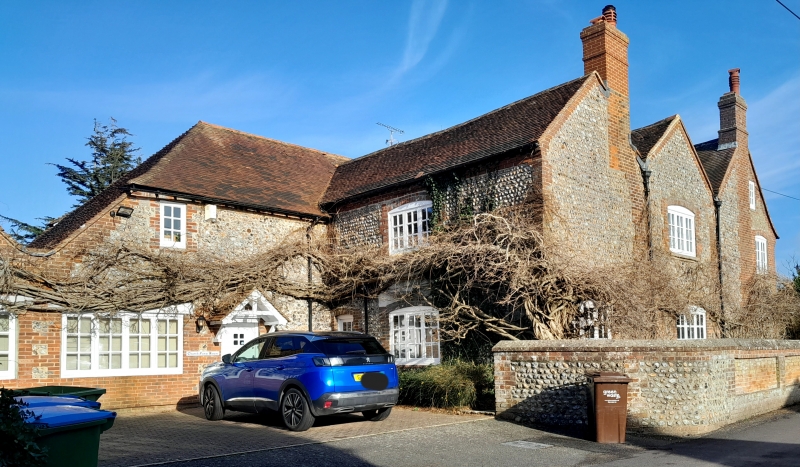
Church Farm House
II
Three parallel ranges. C18. Two storeys. Three windows. East front faced with
flints with dressings, quoins and stringcourse of red brick. South front cobbles.
Tiled roof with three gable ends to the south. Glazing bars intact on first floor
only.
Listing NGR: TQ0660404443
External links are from the relevant listing authority and, where applicable, Wikidata. Wikidata IDs may be related buildings as well as this specific building. If you want to add or update a link, you will need to do so by editing the Wikidata entry.


Other nearby listed buildings
