Approximate Location Map
Large Map »
Latitude: 54.4861 / 54°29'10"N
Longitude: -0.6158 / 0°36'56"W
OS Eastings: 489768
OS Northings: 510968
OS Grid: NZ897109
Mapcode National: GBR SJ4K.GM
Mapcode Global: WHG9Y.HHZQ
Plus Code: 9C6XF9PM+CM
Entry Name: 7, Brunswick Street
Listing Date: 23 February 1954
Grade: II
Source: Historic England
Source ID: 1031353
English Heritage Legacy ID: 326584
ID on this website: 101031353
Location: Whitby, North Yorkshire, YO21
County: North Yorkshire
District: Scarborough
Civil Parish: Whitby
Built-Up Area: Whitby
Traditional County: Yorkshire
Lieutenancy Area (Ceremonial County): North Yorkshire
Church of England Parish: Whitby St Mary
Church of England Diocese: York
Tagged with: Building
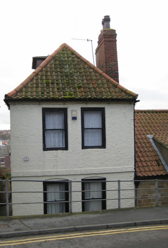
1.
1811 BRUNSWICK STREET
No 7
NZ 8910 3/280 23.2.54.
II CV
2.
C18. 2 storeys in painted brick. Pantile roof, hipped to roof. Bands
between storeys. 2 windows, double-hung sashes, flat arches, flush frames,
no glazing bars. On ground floor, segmental headed recessed doorway wood
architrave
Nos 2 to 10 (consec) form a group with No 16 Flowergate.
Listing NGR: NZ8976810968
External links are from the relevant listing authority and, where applicable, Wikidata. Wikidata IDs may be related buildings as well as this specific building. If you want to add or update a link, you will need to do so by editing the Wikidata entry.


Other nearby listed buildings
