Approximate Location Map
Large Map »
Latitude: 51.4034 / 51°24'12"N
Longitude: 0.1185 / 0°7'6"E
OS Eastings: 547454
OS Northings: 169279
OS Grid: TQ474692
Mapcode National: GBR QD.BKB
Mapcode Global: VHHNZ.0ZHK
Plus Code: 9F32C439+99
Entry Name: The Bull Public House
Listing Date: 29 June 1973
Grade: II
Source: Historic England
Source ID: 1031802
English Heritage Legacy ID: 358524
Also known as: The Bull, Chislehurst
The Bull Inn, St Paul's Cray, Orpington
Bull Inn
ID on this website: 101031802
Location: Bromley, London, BR5
County: London
District: Bromley
Electoral Ward/Division: Cray Valley East
Parish: Non Civil Parish
Built-Up Area: Bromley
Traditional County: Kent
Lieutenancy Area (Ceremonial County): Greater London
Church of England Parish: Cray Valley
Church of England Diocese: Rochester
Tagged with: Pub
MAIN ROAD, ST PAUL'S CRAY
1.
4407
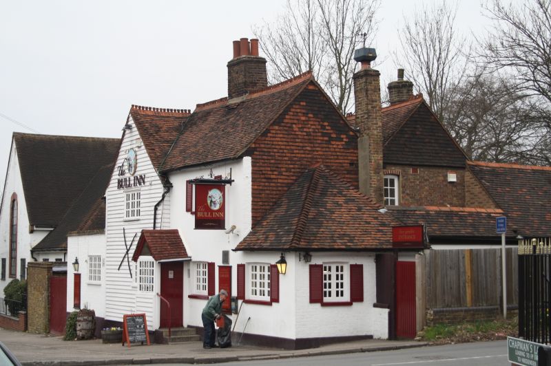
The Bull Public House
TQ 46 NE 9/106
II
2.
2 parallel ranges the front being C18 and the back C19. The front elevation
is weatherboarded. Gable. One window of 3 lights and a C19 porch with
bargeboards.
Listing NGR: TQ4745469279
External links are from the relevant listing authority and, where applicable, Wikidata. Wikidata IDs may be related buildings as well as this specific building. If you want to add or update a link, you will need to do so by editing the Wikidata entry.


Other nearby listed buildings
