Approximate Location Map
Large Map »
Latitude: 52.6282 / 52°37'41"N
Longitude: -2.4872 / 2°29'13"W
OS Eastings: 367120
OS Northings: 303492
OS Grid: SJ671034
Mapcode National: GBR BW.7GDQ
Mapcode Global: WH9DG.R6TH
Plus Code: 9C4VJGH7+74
Entry Name: 8, the Wharfage
Listing Date: 9 August 1974
Grade: II
Source: Historic England
Source ID: 1038672
English Heritage Legacy ID: 362229
ID on this website: 101038672
Location: Ironbridge, Telford and Wrekin, Shropshire, TF8
County: Telford and Wrekin
Civil Parish: The Gorge
Built-Up Area: Telford
Traditional County: Shropshire
Lieutenancy Area (Ceremonial County): Shropshire
Church of England Parish: Ironbridge
Church of England Diocese: Hereford
Tagged with: Building
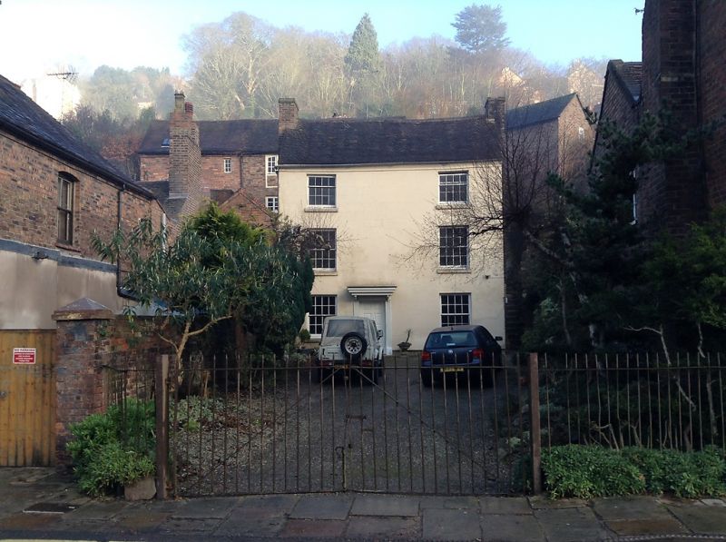
IRONBRIDGE THE WHARFAGE
1.
5362 (north side)
No 8
SJ 6703 SW 15/375 9.8.74
II GV
2.
C18. Engraved stucco; 3 storeys; 3 sash windows with plain lintels; central doorway
now lacking wood surround, with cornice and modern door; plain eaves; old tile roof.
Set back with small garden area in front.
Listing NGR: SJ6712003492
External links are from the relevant listing authority and, where applicable, Wikidata. Wikidata IDs may be related buildings as well as this specific building. If you want to add or update a link, you will need to do so by editing the Wikidata entry.


Other nearby listed buildings
