Approximate Location Map
Large Map »
Latitude: 55.4134 / 55°24'48"N
Longitude: -1.7022 / 1°42'7"W
OS Eastings: 418953
OS Northings: 613313
OS Grid: NU189133
Mapcode National: GBR J5KV.88
Mapcode Global: WHC1K.T6MC
Plus Code: 9C7WC77X+94
Entry Name: Water Tower on West Side of Kitchen Garden
Listing Date: 25 August 1977
Grade: II
Source: Historic England
Source ID: 1041492
English Heritage Legacy ID: 235669
ID on this website: 101041492
Location: Alnwick, Northumberland, NE66
County: Northumberland
Civil Parish: Alnwick
Built-Up Area: Alnwick
Traditional County: Northumberland
Lieutenancy Area (Ceremonial County): Northumberland
Church of England Parish: Alnwick
Church of England Diocese: Newcastle
Tagged with: Water tower
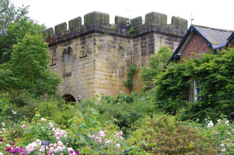
CASTLE GARDENS
1.
5330
Water Tower on west
side of Kitchen Garden
NU 1813 SE 1/201
II
2.
Crenellated tower, before 1851, with projections to north and south. Ashlar.
Archway to east. Arrow slits and merlon lights.
Listing NGR: NU1895413312
External links are from the relevant listing authority and, where applicable, Wikidata. Wikidata IDs may be related buildings as well as this specific building. If you want to add or update a link, you will need to do so by editing the Wikidata entry.


Other nearby listed buildings
