Approximate Location Map
Large Map »
Latitude: 55.7719 / 55°46'18"N
Longitude: -1.9995 / 1°59'58"W
OS Eastings: 400131
OS Northings: 653174
OS Grid: NU001531
Mapcode National: GBR G1GP.XR
Mapcode Global: WH9YK.8640
Plus Code: 9C7WQ2C2+Q6
Entry Name: Gate
Listing Date: 26 May 1971
Grade: I
Source: Historic England
Source ID: 1042478
English Heritage Legacy ID: 237328
ID on this website: 101042478
Location: Berwick-upon-Tweed, Northumberland, TD15
County: Northumberland
Civil Parish: Berwick-upon-Tweed
Built-Up Area: Berwick-upon-Tweed
Traditional County: Northumberland
Lieutenancy Area (Ceremonial County): Northumberland
Church of England Parish: Berwick Holy Trinity and St Mary
Church of England Diocese: Newcastle
Tagged with: City gate
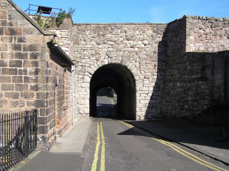
1.
840 COWPORT
Gate
NU 0053 11/80
I
Part of Town Fortifications. Single round arch with tunnel vault. Heavy
wooden doors remain on outer side.
Scheduled A M.
Listing NGR: NU0013153174
External links are from the relevant listing authority and, where applicable, Wikidata. Wikidata IDs may be related buildings as well as this specific building. If you want to add or update a link, you will need to do so by editing the Wikidata entry.


Other nearby listed buildings
