Approximate Location Map
Large Map »
Latitude: 51.37 / 51°22'12"N
Longitude: -0.0078 / 0°0'28"W
OS Eastings: 538771
OS Northings: 165322
OS Grid: TQ387653
Mapcode National: GBR L8.GQD
Mapcode Global: VHGRM.TT7M
Plus Code: 9C3X9XCR+2V
Entry Name: 25, Corkscrew Hill
Listing Date: 29 June 1973
Grade: II
Source: Historic England
Source ID: 1064347
English Heritage Legacy ID: 358413
ID on this website: 101064347
Location: West Wickham, Bromley, London, BR4
County: London
District: Bromley
Electoral Ward/Division: West Wickham
Parish: Non Civil Parish
Built-Up Area: Bromley
Traditional County: Kent
Lieutenancy Area (Ceremonial County): Greater London
Church of England Parish: West Wickham St John
Church of England Diocese: Southwark
Tagged with: Building
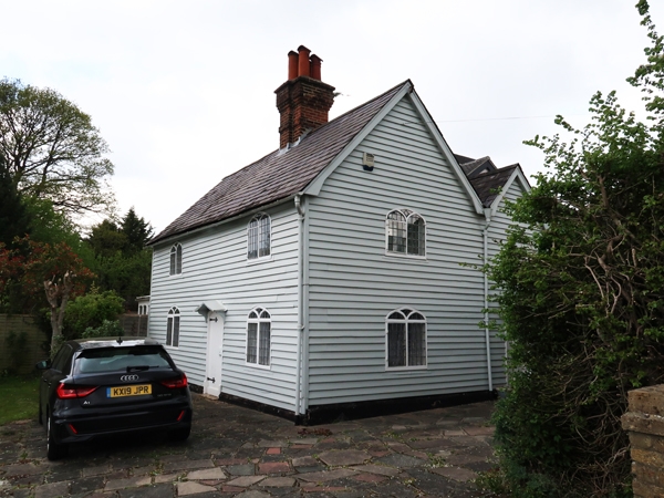
CORKSCREW HILL
1.
4407 WEST WICKHAM
No 25
TQ 36 NE 2/20
II
2.
Early Cl9 cottage of 2 parallel ranges and 2 storeys. Weatherboarded with
slate roof. 2 windows, each a pair of lancets under 2 centred head,
retaining original lead glazing bars. Central door in 4 centred opening.
Listing NGR: TQ3877165322
External links are from the relevant listing authority and, where applicable, Wikidata. Wikidata IDs may be related buildings as well as this specific building. If you want to add or update a link, you will need to do so by editing the Wikidata entry.


Other nearby listed buildings
