Approximate Location Map
Large Map »
Latitude: 51.2432 / 51°14'35"N
Longitude: 0.9626 / 0°57'45"E
OS Eastings: 606875
OS Northings: 153503
OS Grid: TR068535
Mapcode National: GBR SWZ.XXB
Mapcode Global: VHKK9.M0QT
Plus Code: 9F326XV7+72
Entry Name: Wall to Chilham Castle Estate, from Gatehouse South
Listing Date: 13 August 1984
Grade: II
Source: Historic England
Source ID: 1071286
English Heritage Legacy ID: 181471
ID on this website: 101071286
Location: Chilham, Ashford, Kent, CT4
County: Kent
District: Ashford
Civil Parish: Chilham
Built-Up Area: Chilham
Traditional County: Kent
Lieutenancy Area (Ceremonial County): Kent
Tagged with: Wall
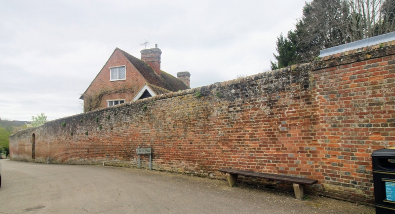
TR 0653-0753 CHILHAM SCHOOL HILL
(south-west side)
7/31 Wall to Chilham
Castle Estate,
from Gatehouse south
GV II
Wall. C18. Chequered brick, approximately 7 foot high. Runs
100 yards down entire length of School Hill to Annagh House.
One Cl9 opening to cottage 35 yards south of gatehouse.
Listing NGR: TR0688253498
External links are from the relevant listing authority and, where applicable, Wikidata. Wikidata IDs may be related buildings as well as this specific building. If you want to add or update a link, you will need to do so by editing the Wikidata entry.


Other nearby listed buildings
