Approximate Location Map
Large Map »
Latitude: 52.093 / 52°5'34"N
Longitude: -1.9474 / 1°56'50"W
OS Eastings: 403697
OS Northings: 243851
OS Grid: SP036438
Mapcode National: GBR 3LB.LH6
Mapcode Global: VHB0T.6NBC
Plus Code: 9C4W33V3+52
Entry Name: 11, High Street
Listing Date: 24 June 1977
Grade: II
Source: Historic England
Source ID: 1081373
English Heritage Legacy ID: 147430
ID on this website: 101081373
Location: Evesham, Wychavon, Worcestershire, WR11
County: Worcestershire
District: Wychavon
Civil Parish: Evesham
Built-Up Area: Evesham
Traditional County: Worcestershire
Lieutenancy Area (Ceremonial County): Worcestershire
Church of England Parish: Evesham All Saints with St Lawrence
Church of England Diocese: Worcester
Tagged with: Building
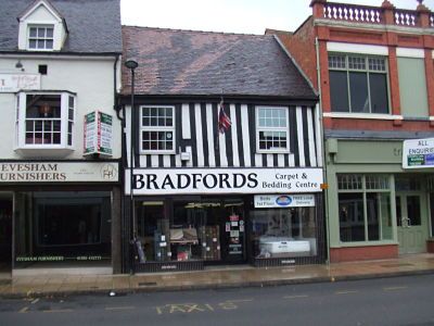
HIGH STREET
1.
5249
(West Side)
No 11
SP 0343 NE 1/201
II GV
2.
Late C16. Timber frame with close set studding and plaster infilling; 2 storeys;
2 sash windows in moulded cases; tiles. Modern shop front.
Nos 3 to 11 (odd) form a group.
Listing NGR: SP0369743851
External links are from the relevant listing authority and, where applicable, Wikidata. Wikidata IDs may be related buildings as well as this specific building. If you want to add or update a link, you will need to do so by editing the Wikidata entry.


Other nearby listed buildings
