Approximate Location Map
Large Map »
Latitude: 53.3595 / 53°21'34"N
Longitude: -2.0083 / 2°0'29"W
OS Eastings: 399547
OS Northings: 384732
OS Grid: SJ995847
Mapcode National: GBR GYFL.0F
Mapcode Global: WHBB5.3TYF
Plus Code: 9C5V9X5R+QM
Entry Name: Footbridge at New Mills Station
Listing Date: 19 September 1977
Grade: II
Source: Historic England
Source ID: 1088139
English Heritage Legacy ID: 81821
ID on this website: 101088139
Location: Newtown, High Peak, Derbyshire, SK22
County: Derbyshire
District: High Peak
Civil Parish: New Mills
Built-Up Area: New Mills
Traditional County: Cheshire
Lieutenancy Area (Ceremonial County): Derbyshire
Church of England Parish: Disley St Mary
Church of England Diocese: Chester
Tagged with: Railway footbridge
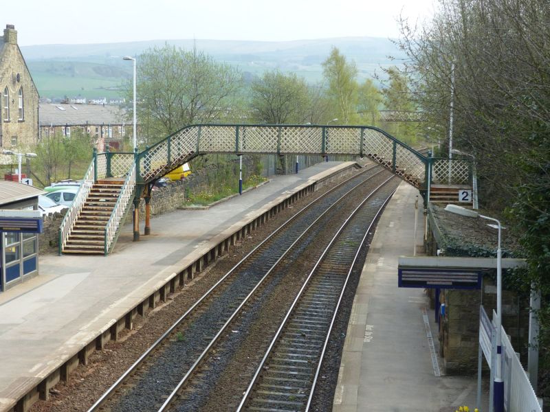
NEW MILLS BUXTON ROAD
1.
5172
(East Side)
Footbridge at
New Mills Station
SJ 98 SE 5/105
II
2.
Mid C19 cast iron footbridge with ornamental balusters and steps up which are supported
on iron columns with knob finials, trellis pattern sides to top platform over the
tracks. A similar footbridge at Furness Vale Station.
Listing NGR: SJ9954784732
External links are from the relevant listing authority and, where applicable, Wikidata. Wikidata IDs may be related buildings as well as this specific building. If you want to add or update a link, you will need to do so by editing the Wikidata entry.


Other nearby listed buildings
