Approximate Location Map
Large Map »
Latitude: 51.3903 / 51°23'24"N
Longitude: 0.3996 / 0°23'58"E
OS Eastings: 567052
OS Northings: 168423
OS Grid: TQ670684
Mapcode National: GBR NN5.ZSJ
Mapcode Global: VHJLR.WB32
Plus Code: 9F3299RX+4R
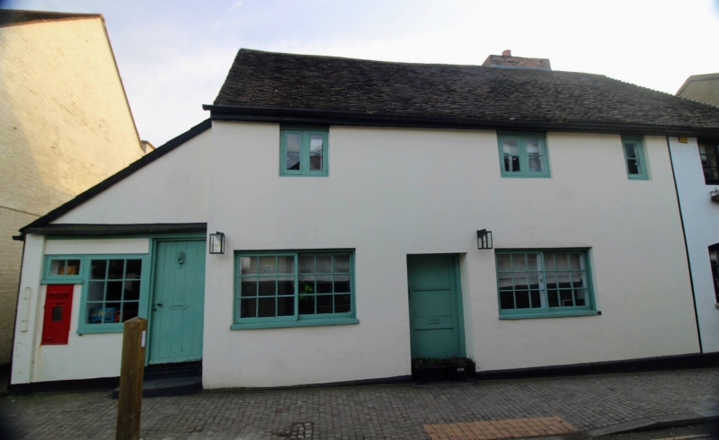
Entry Name: The Old Post Office
Listing Date: 26 July 1983
Grade: II
Source: Historic England
Source ID: 1096315
English Heritage Legacy ID: 356740
ID on this website: 101096315
Location: Cobham, Gravesham, Kent, DA12
County: Kent
District: Gravesham
Civil Parish: Cobham
Built-Up Area: Cobham
Traditional County: Kent
Lieutenancy Area (Ceremonial County): Kent
Church of England Parish: Cobham St Mary Magdalene
Church of England Diocese: Rochester
Tagged with: Post office
TQ 66 NE COBHAM THE STREET
5/14 (south side)
Nos 45 to 49 (odd)
GV (The Post Office)
II
Probably C16 hall house. Timber-framed. Now stucco faced with weatherboarded west
end. Upper part tile-hung at rear with single storey projection. Tiled hipped roof.
Casement windows. Much original timber-framing visible internally.
Listing NGR: TQ6704668420
External links are from the relevant listing authority and, where applicable, Wikidata. Wikidata IDs may be related buildings as well as this specific building. If you want to add or update a link, you will need to do so by editing the Wikidata entry.


Other nearby listed buildings
