Approximate Location Map
Large Map »
Latitude: 50.582 / 50°34'55"N
Longitude: -3.4664 / 3°27'58"W
OS Eastings: 296278
OS Northings: 76834
OS Grid: SX962768
Mapcode National: GBR P2.RCDN
Mapcode Global: FRA 37MJ.HCM
Plus Code: 9C2RHGJM+RF
Entry Name: 1-7, Exeter Road
Listing Date: 17 July 1951
Last Amended: 21 March 1985
Grade: II
Source: Historic England
Source ID: 1096648
English Heritage Legacy ID: 84368
ID on this website: 101096648
Location: Dawlish, Teignbridge, Devon, EX7
County: Devon
District: Teignbridge
Civil Parish: Dawlish
Built-Up Area: Dawlish
Traditional County: Devon
Lieutenancy Area (Ceremonial County): Devon
Church of England Parish: Dawlish St Gregory
Church of England Diocese: Exeter
Tagged with: Building Thatched cottage
SX 9676 DAWLISH EXTER ROAD
8/53 Nos 1 to 7 (odd)
(formerly listed as Nos
17.7.51 1 to 4 consec)
- II
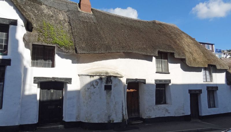
Modernised C16 farmhouse or cottages with date tablet 1539. 2 storeys.
Cob walls supported by buttresses. Thatched roof. One rounded projection
on road front. Modern leaded casements.
Listing NGR: SX9627876834
External links are from the relevant listing authority and, where applicable, Wikidata. Wikidata IDs may be related buildings as well as this specific building. If you want to add or update a link, you will need to do so by editing the Wikidata entry.


Other nearby listed buildings
