Approximate Location Map
Large Map »
Latitude: 50.5252 / 50°31'30"N
Longitude: -3.5314 / 3°31'53"W
OS Eastings: 291542
OS Northings: 70607
OS Grid: SX915706
Mapcode National: GBR P1.45SH
Mapcode Global: FRA 37HN.VDN
Plus Code: 9C2RGFG9+3C
Entry Name: Rock Cottage
Listing Date: 2 December 1988
Grade: II
Source: Historic England
Source ID: 1097637
English Heritage Legacy ID: 86016
ID on this website: 101097637
Location: Stokeinteignhead, Teignbridge, Devon, TQ12
County: Devon
District: Teignbridge
Civil Parish: Stokeinteignhead
Built-Up Area: Stokeinteignhead
Traditional County: Devon
Lieutenancy Area (Ceremonial County): Devon
Church of England Parish: Stokeinteignhead St Andrew
Church of England Diocese: Exeter
Tagged with: Cottage Thatched cottage
STOKEINTEIGNHEAD FORCHES HILL, Stokeinteignhead
SX 9070-9170
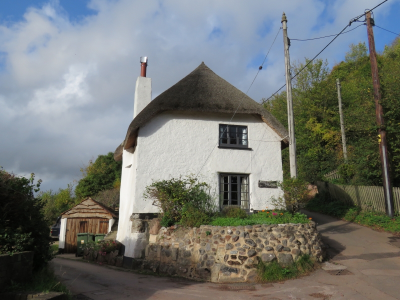
17/370 Rock Cottage
-
GV II
Cottage. Probably C17 or earlier, C20 addition on left end. Whitewashed rendered
cob and stone rubble; thatched roof, half-hipped at right end, gabled at left end;
projecting front lateral stack with set-offs.
Plan: Probably a 2 room plan with a central entrance. The right hand room is heated
from a front lateral stack. The left hand room has a stack at the left end, but it
may have been unheated originally. In the C20 a single-storey extension was added to
the left end.
Exterior: 2 storeys. Asymmetrical 1 window front with a C20 front door to the left
of the stack, 1 small ground floor window and 1 first floor C20 3-light timber
casement with glazing bars. The right return has 1 first floor 3-light timber
casement with glazing bars. The rear elevation, backing onto Forches Hill, has 1
first and 1 ground floor 2-light timber casement with glazing bars and 1 small ground
floor C20 window. Plaster armorial bearing with supporters of unknown date on the
rear wall. These are identical to the armorial bearings in Old Bailey Farmhouse
(q.v.).
Interior: Access to interior unobtainable at time of survey (1987) but said to have
exposed carpentry.
Listing NGR: SX9154270607
External links are from the relevant listing authority and, where applicable, Wikidata. Wikidata IDs may be related buildings as well as this specific building. If you want to add or update a link, you will need to do so by editing the Wikidata entry.


Other nearby listed buildings
