Approximate Location Map
Large Map »
Latitude: 50.7428 / 50°44'34"N
Longitude: -3.0716 / 3°4'17"W
OS Eastings: 324482
OS Northings: 94236
OS Grid: SY244942
Mapcode National: GBR PD.VQ70
Mapcode Global: FRA 47G3.TBY
Plus Code: 9C2RPWVH+48
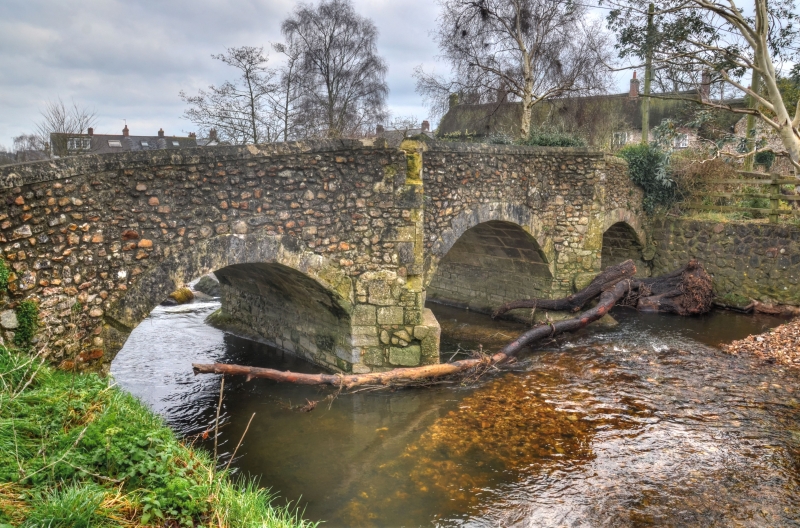
Entry Name: Chantry Bridge
Listing Date: 8 May 1967
Grade: II
Source: Historic England
Source ID: 1098511
English Heritage Legacy ID: 87922
ID on this website: 101098511
Location: Colyton, East Devon, EX24
County: Devon
District: East Devon
Civil Parish: Colyton
Built-Up Area: Colyton
Traditional County: Devon
Lieutenancy Area (Ceremonial County): Devon
Church of England Parish: Colyton St Andrew
Church of England Diocese: Exeter
Tagged with: Bridge
SY 2494 COLYTON VICARAGE STREET
24/216 COLYTON
8.5.67 Chantry Bridge
GV
II
Road bridge over River Coly. Circa C18. Stone rubble. Three spans with segmental
ashlar arches and cutwaters both sides with refuges in the parapets which have plain
chamfered coping.
Listing NGR: SY2448294236
External links are from the relevant listing authority and, where applicable, Wikidata. Wikidata IDs may be related buildings as well as this specific building. If you want to add or update a link, you will need to do so by editing the Wikidata entry.


Other nearby listed buildings
