Approximate Location Map
Large Map »
Latitude: 53.0486 / 53°2'54"N
Longitude: -1.7389 / 1°44'20"W
OS Eastings: 417600
OS Northings: 350181
OS Grid: SK176501
Mapcode National: GBR 489.Z1V
Mapcode Global: WHCDZ.8M6Q
Plus Code: 9C5W27X6+CC
Entry Name: Cherry Orchard Farmhouse and Attached Outbuildings
Listing Date: 5 February 1952
Grade: II*
Source: Historic England
Source ID: 1109314
English Heritage Legacy ID: 80304
ID on this website: 101109314
Location: Fenny Bentley, Derbyshire Dales, Derbyshire, DE6
County: Derbyshire
District: Derbyshire Dales
Civil Parish: Fenny Bentley
Traditional County: Derbyshire
Lieutenancy Area (Ceremonial County): Derbyshire
Church of England Parish: Fenny-Bentley St Edmund the King and Martyr
Church of England Diocese: Derby
Tagged with: Farmhouse
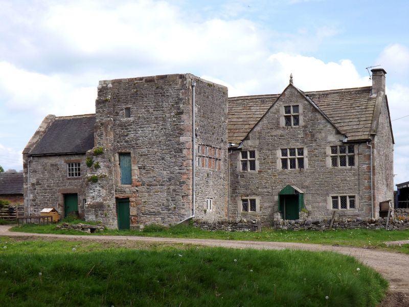
SK 15 SE PARISH OF FENNY BENTLEY BUXTON ROAD
5/33 (East Side)
5.2.1952 Cherry Orchard Farmhouse and
attached outbuildings
II*
Pele tower, now farmhouse. Medieval and late C17. Coursed rubble limestone with
sandstone dressings. Stone slate and plain tile roofs, stone coped gables with
plain kneelers at the south end and stone coped gable at the north end. Stone
gable end stacks. Two storeys. Three storey late Medieval tower projecting on
the west side. Angle quoins and at the north west corner a large buttress with
six set-offs. West elevation with a doorway to the ground floor and a doorway
above with chamfered surround and small opening above again. South elevation with a
later 2-light chamfered mullion window to the ground floor and a partly blocked
7-light mullioned and transomed window above. The crenellated parapet has been
removed. Original stone newel staircase inside. West elevation of the house, three
bays with a gable. Central doorway with stone surround and C20 wooden porch.
Flanked on the left by a 2-light chamfered mullion window and on the right by a
similar 3-light window. Central 3-light mullioned and transomed window above with
a similar 2-light window to the left and a similar 3-light window to the right. In
the gable above, a similar 2-light mullioned and transomed window. All the windows
have C20 diamond leaded lights. Two storey outbuildings attached at the north end.
It has been suggested that the tower is the gatehouse of the moated hall which
stood nearby.
Listing NGR: SK1760050181
External links are from the relevant listing authority and, where applicable, Wikidata. Wikidata IDs may be related buildings as well as this specific building. If you want to add or update a link, you will need to do so by editing the Wikidata entry.


Other nearby listed buildings
