Approximate Location Map
Large Map »
Latitude: 50.7998 / 50°47'59"N
Longitude: -3.1882 / 3°11'17"W
OS Eastings: 316359
OS Northings: 100697
OS Grid: ST163006
Mapcode National: GBR LX.YXTF
Mapcode Global: FRA 466Z.HQ3
Plus Code: 9C2RQRX6+WP
Entry Name: 68, High Street
Listing Date: 21 March 1972
Grade: II
Source: Historic England
Source ID: 1116677
English Heritage Legacy ID: 442956
ID on this website: 101116677
Location: Honiton, East Devon, EX14
County: Devon
District: East Devon
Civil Parish: Honiton
Built-Up Area: Honiton
Traditional County: Devon
Lieutenancy Area (Ceremonial County): Devon
Church of England Parish: Honiton with Monkton
Church of England Diocese: Exeter
Tagged with: Building
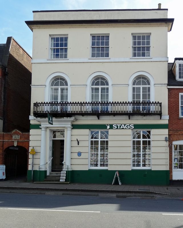
1. HIGH STREET
1228 (South Side)
No 68
ST 1600 1/65
II GV
2.
Probably 1850-40 3 storey 3 window stucco front Arched windows and continuous
cast iron balcony at 1st floor . Rusticated ground floor-without glazing
bars to tie windows, Tuscan doorcase, radial bar fanlight.
Nos 68 and 72 to 78 (even) form a group.
Listing NGR: ST1636200696
External links are from the relevant listing authority and, where applicable, Wikidata. Wikidata IDs may be related buildings as well as this specific building. If you want to add or update a link, you will need to do so by editing the Wikidata entry.


Other nearby listed buildings
