Approximate Location Map
Large Map »
Latitude: 50.8016 / 50°48'5"N
Longitude: -3.1831 / 3°10'59"W
OS Eastings: 316722
OS Northings: 100898
OS Grid: ST167008
Mapcode National: GBR LX.YZ98
Mapcode Global: FRA 466Z.CQC
Plus Code: 9C2RRR28+MQ
Entry Name: Marwood House
Listing Date: 1 June 1949
Grade: II*
Source: Historic England
Source ID: 1116982
English Heritage Legacy ID: 442469
ID on this website: 101116982
Location: Honiton, East Devon, EX14
County: Devon
District: East Devon
Civil Parish: Honiton
Built-Up Area: Honiton
Traditional County: Devon
Lieutenancy Area (Ceremonial County): Devon
Church of England Parish: Honiton with Monkton
Church of England Diocese: Exeter
Tagged with: House
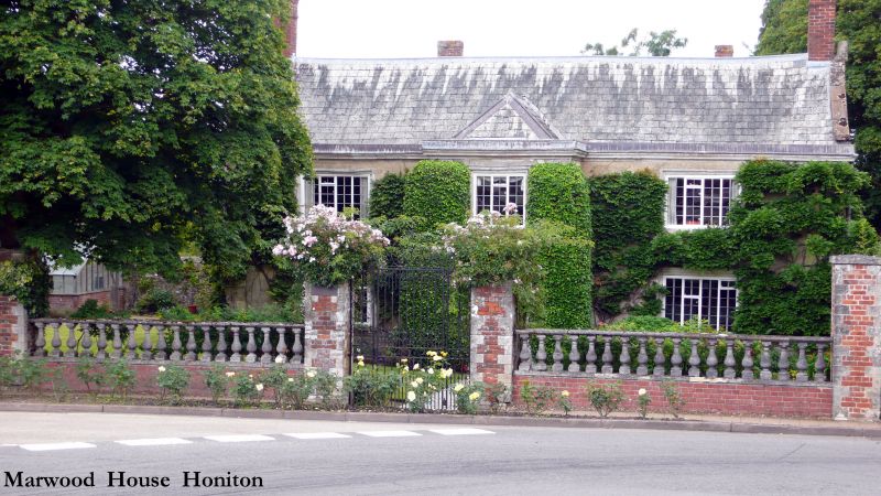
1. HIGH STREET
1228 (North Side)
Marwood House
ST 1600 3/95 1.6.49
II*
2.
1619, built by the son of Queen Elizabeth's physician, 2 storey stone with
projecting central porch wing. Stone cornice and parapet. 3- and 4-light
stone windows, casements mainly new. Original 4-centred arches and panelled
door to entrance. Slate roof.
Listing NGR: ST1672200898
External links are from the relevant listing authority and, where applicable, Wikidata. Wikidata IDs may be related buildings as well as this specific building. If you want to add or update a link, you will need to do so by editing the Wikidata entry.


Other nearby listed buildings
