Approximate Location Map
Large Map »
Latitude: 53.6137 / 53°36'49"N
Longitude: -1.8159 / 1°48'57"W
OS Eastings: 412275
OS Northings: 413032
OS Grid: SE122130
Mapcode National: GBR HVRN.NB
Mapcode Global: WHCB7.2FKJ
Plus Code: 9C5WJ57M+FJ
Entry Name: Netherton Well
Listing Date: 9 December 1986
Last Amended: 5 February 1987
Grade: II
Source: Historic England
Source ID: 1126563
English Heritage Legacy ID: 422763
ID on this website: 101126563
Location: Netherton, Kirklees, West Yorkshire, HD4
County: Kirklees
Electoral Ward/Division: Crosland Moor and Netherton
Parish: Non Civil Parish
Built-Up Area: Netherton
Traditional County: Yorkshire
Lieutenancy Area (Ceremonial County): West Yorkshire
Church of England Parish: South Crosland Holy Trinity
Church of England Diocese: Leeds
Tagged with: Building
This list entry was subject to a Minor Amendment on 20 September 2021 to remove superfluous amendment details and to reformat the text to current standards
SE 1213 & SE 1313
47/1436
Netherton
MELTHAM ROAD (north-west side)
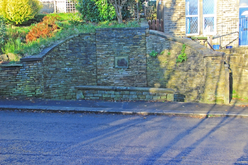
Netherton Well
(Formerly listed as Netherton Well including conduit and stone trough)
GV
II
Well-head with retaining walls. C19. Coursed squared stone. Well set in recess of curved retaining wall flanked by paved ar and low roadside wall. Tall rear retaining wall has taller central section flanked by slightly recessed quadrant walls sloping down towards road; well recess at low level in centre has monolithic sill and lintel and later engraved stone notice warning against damage set above; flat stone coping with pyramidal end-stones. Partially-paved area in front and low roadside wall with chamfered coping. This watering point was a feature of the Lockwood to Meltham Road when it was turnpiked by Act of Parliament in 1818.
Listing NGR: SE1227513032
External links are from the relevant listing authority and, where applicable, Wikidata. Wikidata IDs may be related buildings as well as this specific building. If you want to add or update a link, you will need to do so by editing the Wikidata entry.


Other nearby listed buildings
