Approximate Location Map
Large Map »
Latitude: 54.4842 / 54°29'2"N
Longitude: -1.5581 / 1°33'29"W
OS Eastings: 428727
OS Northings: 509957
OS Grid: NZ287099
Mapcode National: GBR KJKL.GB
Mapcode Global: WHC63.1KB7
Plus Code: 9C6WFCMR+MQ
Entry Name: Monk End Hall
Listing Date: 18 March 1968
Last Amended: 29 January 1988
Grade: II
Source: Historic England
Source ID: 1131331
English Heritage Legacy ID: 322678
ID on this website: 101131331
Location: Croft-on-Tees, North Yorkshire, DL2
County: North Yorkshire
District: Richmondshire
Civil Parish: Croft-on-Tees
Traditional County: Yorkshire
Lieutenancy Area (Ceremonial County): North Yorkshire
Church of England Parish: Croft
Church of England Diocese: Leeds
Tagged with: Architectural structure
CROFT-ON-TEES MONKEND
NZ 2809-2909
(west side)
10/39 Monk End Hall
(formerly listed as Monk
18.3.68 End)
GV II
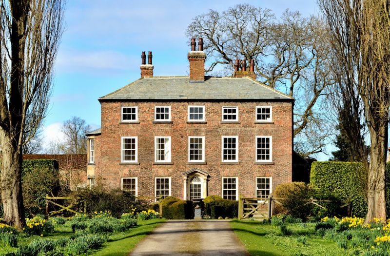
House. Mainly early C18, with older, possibly C16, origins and later
alterations. Brown brick, Westmorland slate roof. U-shaped plan, main
range of 3 storeys and 5 bays. East front: central part-glazed door below
fanlight with decorative glazing bars in round-arched ashlar surround with
Roman Doric 3/4 columns, with fluted capitals and paterae on entablature,
supporting open pediment. Renewed sash window with glazing bars, exposed
sash boxes, ashlar sills and deep flat brick arches, the second-floor
windows of 6 panes, the central one blind. Brick dentil eaves course.
Hipped roof. Large central stack. Rear: to basement, 2-light chamfered
mullion window, of red sandstone, with iron stanchions; older, steeper
gables of M-shaped roof. Left return: sandstone rubble; 2 storeys; to left,
on each floor, a C20 sash window with glazing bars; to right a 2-storey
canted bay window of sashes with glazing bars set in ashlar sandstone having
Roman Doric 3/4 columns, with hipped roof. Right return: projection which may
be early chimney stack; bell attached at high level. To the rear right is a
lower kitchen range. The conservatory was once used as a school room. On
the house are several lead rainwater pipes with fluted hopper-heads.
Listing NGR: NZ2872709957
External links are from the relevant listing authority and, where applicable, Wikidata. Wikidata IDs may be related buildings as well as this specific building. If you want to add or update a link, you will need to do so by editing the Wikidata entry.


Other nearby listed buildings
