History in Structure

9 Miles Post Between Holme and Lane

A Grade II Listed Building in Holme Valley, Kirklees

More Photos »
Approximate Location Map
Large Map »

Coordinates

Latitude: 53.548 / 53°32'52"N

Longitude: -1.8405 / 1°50'25"W

OS Eastings: 410667

OS Northings: 405723

OS Grid: SE106057

Mapcode National: GBR HWLD.BV

Mapcode Global: WHCBL.P2ST

Plus Code: 9C5WG5X5+6R

Entry Name: 9 Miles Post Between Holme and Lane

Listing Date: 4 August 1983

Grade: II

Source: Historic England

Source ID: 1134743

English Heritage Legacy ID: 340647

ID on this website: 101134743

Location: Holme, Kirklees, West Yorkshire, HD9

County: Kirklees

Civil Parish: Holme Valley

Traditional County: Yorkshire

Lieutenancy Area (Ceremonial County): West Yorkshire

Church of England Parish: Holmbridge St David

Church of England Diocese: Leeds

Tagged with: Building Milestone

Find accommodation in
Holmbridge

Description


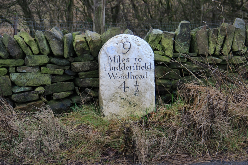
SE 10 NW WOODHEAD ROAD
4/419 (Holme)

9 Miles Post between
Holme and Lane

II


Mile post. Early to mid C19. Painted stone post with rounded top with inscription:
9
Miles to
Huddersfield
Woodhead


Listing NGR: SE1066705723

External Links

External links are from the relevant listing authority and, where applicable, Wikidata. Wikidata IDs may be related buildings as well as this specific building. If you want to add or update a link, you will need to do so by editing the Wikidata entry.

Recommended Books

Other nearby listed buildings

BritishListedBuildings.co.uk is an independent online resource and is not associated with any government department. All government data published here is used under licence. Please do not contact BritishListedBuildings.co.uk for any queries related to any individual listed building, planning permission related to listed buildings or the listing process itself.

British Listed Buildings is a Good Stuff website.