Approximate Location Map
Large Map »
Latitude: 50.2491 / 50°14'56"N
Longitude: -5.1762 / 5°10'34"W
OS Eastings: 173660
OS Northings: 43617
OS Grid: SW736436
Mapcode National: GBR Z6.0KFB
Mapcode Global: FRA 081C.P7X
Plus Code: 9C2P6RXF+JG
Entry Name: Engine House at Approximately 50M North West of Wheal Bush Farmhouse Killifreth Mine
Listing Date: 30 May 1967
Last Amended: 3 February 1986
Grade: II
Source: Historic England
Source ID: 1140973
English Heritage Legacy ID: 63096
ID on this website: 101140973
Location: Little Beside, Cornwall, TR16
County: Cornwall
Civil Parish: Chacewater
Traditional County: Cornwall
Lieutenancy Area (Ceremonial County): Cornwall
Church of England Parish: Chacewater
Church of England Diocese: Truro
Tagged with: Engine house Agricultural structure
CHACEWATER
SW 74 SW
4/38 Engine house at approx 50m north
west of Wheal Bush Farmhouse
30.5.67 Killifreth Mine.
(Formerly listed as part of two
engine houses at New Shaft,
Killifreth Mine)
GV II
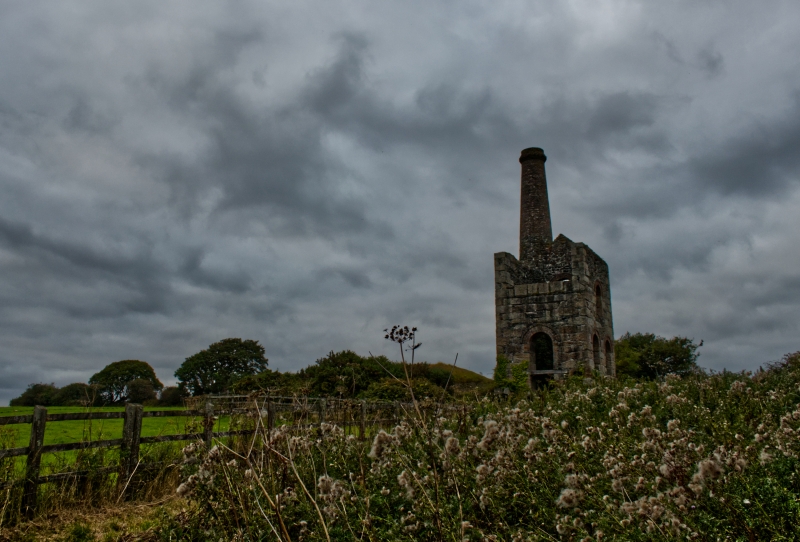
Beam engine house ruin. Circa mid-late C19. Mostly killas rubble with granite
quoins, jambstone and bonding stones and mostly dressed coursed granite facing to bob
(south west) wall. Round 2-stage chimney to north corner. Round brick arches over
openings and brick upper stage to chimney. Originally with gable ended roof and 3
floors; now roofless and floorless. Rectangular single-cell plan with thicker bob
wall overlooking mine shaft to south east and round chimney north corner. Originally
3 storeys. Walls virtually intact except for what was framed and weather-boarded wall
to second floor and gable end over bob wall. Some undermining of jambs to ground
floor opening of bob wall when machinery removed C20.
Wheal Bush was part of Unity Wood and Killifreth Mine. This mine was re-opened in
1865 and this is one of two engine houses in a group, probably for pumping.
Listing NGR: SW7366043617
External links are from the relevant listing authority and, where applicable, Wikidata. Wikidata IDs may be related buildings as well as this specific building. If you want to add or update a link, you will need to do so by editing the Wikidata entry.


Other nearby listed buildings
