Approximate Location Map
Large Map »
Latitude: 54.6053 / 54°36'19"N
Longitude: -2.7579 / 2°45'28"W
OS Eastings: 351137
OS Northings: 523614
OS Grid: NY511236
Mapcode National: GBR 9H55.QX
Mapcode Global: WH81J.LHXV
Plus Code: 9C6VJ64R+4R
Entry Name: Brookside
Listing Date: 31 January 1991
Grade: II
Source: Historic England
Source ID: 1145278
English Heritage Legacy ID: 74425
ID on this website: 101145278
Location: Askham, Westmorland and Furness, Cumbria, CA10
County: Cumbria
District: Eden
Civil Parish: Askham
Traditional County: Westmorland
Lieutenancy Area (Ceremonial County): Cumbria
Church of England Parish: Askham with Lowther
Church of England Diocese: Carlisle
Tagged with: Building
NY 5023
NY 5123
16/27
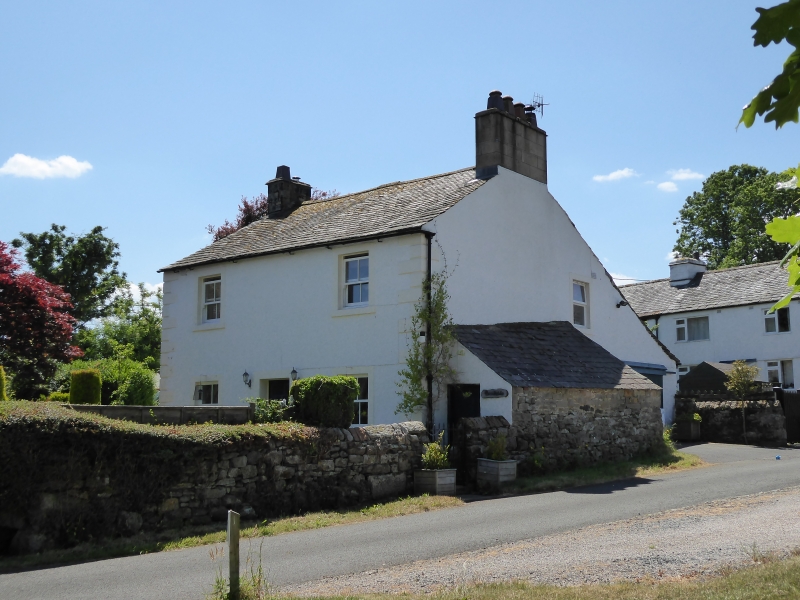
ASKHAM,
Brookside
GV
II
House. Late C18. Painted roughcast walls with painted V-jointed quoins, under
graduated green slate roof with banded limestone chimney stacks. 2 storeys,
2 bays. Windows have plain surrounds and are sashed with glazing bars. Central
panelled door in painted stone surround.
Listing NGR: NY5113723614
External links are from the relevant listing authority and, where applicable, Wikidata. Wikidata IDs may be related buildings as well as this specific building. If you want to add or update a link, you will need to do so by editing the Wikidata entry.


Other nearby listed buildings
