Approximate Location Map
Large Map »
Latitude: 54.5764 / 54°34'35"N
Longitude: -2.4907 / 2°29'26"W
OS Eastings: 368374
OS Northings: 520243
OS Grid: NY683202
Mapcode National: GBR CH1J.K8
Mapcode Global: WH92Z.Q74H
Plus Code: 9C6VHGG5+HP
Entry Name: 36 Boroughgate
Listing Date: 6 June 1951
Last Amended: 26 March 2021
Grade: II*
Source: Historic England
Source ID: 1145578
English Heritage Legacy ID: 73652
ID on this website: 101145578
Location: Appleby-in-Westmorland, Westmorland and Furness, Cumbria, CA16
County: Cumbria
District: Eden
Civil Parish: Appleby-in-Westmorland
Built-Up Area: Appleby-in-Westmorland
Traditional County: Westmorland
Lieutenancy Area (Ceremonial County): Cumbria
Church of England Parish: Appleby St Lawrence
Church of England Diocese: Carlisle
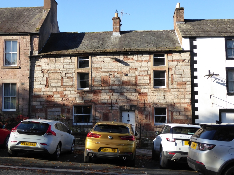
House, mid-C17 with C19 and C20 alterations.
House, mid-C17 with C19 and C20 alterations.
PLAN: cross-passage plan, with a rear rectangular range comprising a stair hall and service rooms.
MATERIALS: regularly coursed and squared buff and red sandstone blocks to the main elevation, coursed rubble to the rear; a Westmorland slate roof in diminishing courses, with stone slate edging.
EXTERIOR: the building is situated on the north side of the main medieval thoroughfare which slopes gently down to the north. This stone-built house has a pitched slate roof with a central chimneystack.
The main east elevation has three storeys plus a partial basement, and two bays. It has a chamfered plinth with a single, barred basement window. The off-centre C17 entrance has moulded jambs and a battlemented lintel, decorated with two flower motifs; it is fitted with a plank door, and there is a tethering ring to the right side associated with an area of worn stonework. To either side of the entrance is a rectangular window with a C20 horned sash, that to the left with bars, and both in tooled, monolithic red sandstone surrounds. There are two similar (but smaller) windows to the first and second floors, the first floor lintels carrying the upper storey sills. The present fenestration dates from the C19, but the elevation contains several blocked C17 windows: two two-light mullioned windows to the upper floor and three blocked three-light windows to the first floor. There is also a blocked fire window lighting an inglenook immediately to the left of the main entrance, and a blocked C17 window further to the left.
The rear elevation has two storeys and three bays and is of rubble sandstone construction beneath a pitched roof. All window and door openings are recent insertions in modern surrounds, a door and one window with earlier relieving arches above and one window with an earlier stone lintel above.
INTERIOR: the main entrance enters the cross-passage which is open to the room to the right; the latter has a chamfered ceiling beam and a small stone chimney piece, and a blocked opening to the north wall. The opposing cross-passage entrance, which pierces the original rear wall of the building, has a cambered head supported on an internal timber lintel and external stone lintel; it is fitted with a plank and batten door. An opening through the cross passage wall at its western end gives access to a short heck passage which opens into the main living room through a four-panel door, and gives entry to the staircase to the right. This living room has a single chamfered ceiling beam and a blocked opening and a pantry to the west wall. A large inglenook to the north wall retains a bressumer beam which terminates at an area of panelling, which may preserve the original heck post. The moulded chimney piece is of later-C17 or early-C18 date and has an inserted C19 cast-iron range.
The ground floor of the rear range is accessed by an extension to the cross passage with a room off to right and left. The room to the right has a wide-boarded door with upper ventilation holes and a stone-flagged floor. To the north wall there is a blocked stone moulded chimney piece, and to its left a moulded round-headed niche with a substantial stone lintel, thought to be a former bread oven. The room to the left has a blocked chamfered sandstone mullion window with timber lintel and stone sill in the south wall. Very worn stone steps lead down to a small cellar with shelving niches, that run back beneath the parlour.
A plain straight-flight stair rises from a full-height rear stair hall. A section of original balustrade with chunky stick balusters remains to the first floor rear L-shaped landing, which separates a pair of rooms occupying the first floor of the rear range, one retaining a stone fire surround. A wide opening through the original rear wall of the building leads back into the original front range, which is partitioned into a pair of rooms with ceiling beams, and re-used panelled doors some of C17 date; one of these partitions incorporates an un-plastered section of what is thought to be a wattle and daub panel. There is a small timber chimney piece to one of the rooms. A cupboard with a re-used seven-panel door retains a timber-framed panel of lath and plaster. A seven-panel door contains an enclosed straight stair flight rising to the second floor of the front range. This is partitioned into a pair of rooms, also with re-used early doors.
Within these spaces an original roof structure is retained and clearly visible: it comprises three raised and pegged cruck trusses with collars (one missing) and double side purlins: two of the crucks display clear assembly marks in sequence, that to the third truss is not visible. The upper part of the roof structure is visible within the enclosed attic space above and, where they are visible, the apex of the crucks are tennoned into a ridge purlin. At the north end of the roof structure immediately in front of the stone gable party wall there is a short crown post supporting the end of the ridge purlin: this is crudely formed and has been spliced into the gable end of the ridge piece.
SUBSIDIARY ITEMS: set to the front of the house is a low stone wall with a double chamfered coping and replacement railings with a quoined central opening (partially rebuilt to the left side in the early C21).
36 Boroughgate is situated between the church to the north and the castle to the south, on the west side of the main medieval thoroughfare of Appleby. The presence of a cross-passage plan and a four-bay cruck-framed roof structure all point to the building having at least C17 origins. In 2020 dendrochronology demonstrated conclusively that the cruck roof structure and the floor structure were coeval and dated to in or around AD 1677-1678, with the exception of a pair of re-used purlins felled at the end of the C16 or the early C17. Furthermore it appears that samples from three ceiling beams matched samples from three tie-beams taken at high levels, suggesting that most of the timber was cut from the same tree. A range of dates was obtained from the rear, western extension, which strongly suggest that it dates to the mid-C18. However, it is considered that the mid-C18 extension incorporates part of an earlier rear range including an original stair turret. The timber source for the building is considered to have been highly local.
The 1754 Appleby town plan depicts 36 Boroughgate as a rectangular-plan building with an attached linear range set to the south end of the rear elevation, thought to incorporate a stair turret and service rooms. The Tithe map of 1843 suggests that by the mid-C19 the rear elevation of the building had been modified and extended, and the former attached linear range had been truncated and detached. On the 1859 1:500 town plan the building is annotated 'Black Bull PH' which is repeated on the revised 1897 Ordnance Survey map; historic newspapers record the building as the Black Bull public house from at least 1814 until at least the 1930s. During its C19 use as a public house, the east elevation was remodelled: the C17 mullioned windows were blocked and a pair of windows to each floor inserted. During the later C20 the building was converted to hotel use and the rooms to the upper floors were sub-divided, and for a time it was linked by a ground floor doorway to the adjacent White Hart. It became a separate property again in the early 1990s when it was converted to a dwelling. In 2009 the fenestration of the rear elevation was remodelled.
36 Boroughgate, of late-C17 date, is listed at Grade II* for the following principal reasons:
Architectural interest:
* an imposing three-storey dwelling of considerable external architectural quality, constructed in the local vernacular of red sandstone and Westmorland slate;
* the exterior retains a wealth of character including a carved door lintel and blocked openings including numerous mullioned windows, revealing its evolution over three and a half centuries;
* for the retention of its cross-passage plan-form including a camber-headed cross-passage entrance, former fire window lighting an inglenook with heck passage and Bressumer beam;
* for a wealth of internal features, fixtures and fittings including C17 carpentry, chimney pieces, doors, chamfered beams, and stair balustrade;
* for the retention of an entire late-C17 raised and pegged cruck roof structure, that retains extensive evidence of late-C17 carpentry;
* dendrochronology has revealed that the house was largely constructed with highly locally sourced timber felled AD 1677-1678, and that remarkably, most of the timber sampled from the house was cut from the same tree.
Group value:
* the building also benefits from a spatial group value with numerous and diverse listed buildings in the vicinity, including a number of contemporary commercial and domestic buildings.
External links are from the relevant listing authority and, where applicable, Wikidata. Wikidata IDs may be related buildings as well as this specific building. If you want to add or update a link, you will need to do so by editing the Wikidata entry.


Other nearby listed buildings
