Approximate Location Map
Large Map »
Latitude: 54.4345 / 54°26'4"N
Longitude: -0.7247 / 0°43'28"W
OS Eastings: 482822
OS Northings: 505096
OS Grid: NZ828050
Mapcode National: GBR RKC5.X3
Mapcode Global: WHF8Y.VS3S
Plus Code: 9C6XC7MG+R4
Entry Name: North York Moors Railway Pedestrian Subway Approximately 110 Metres Long
Listing Date: 7 July 1989
Grade: II*
Source: Historic England
Source ID: 1148752
English Heritage Legacy ID: 327614
ID on this website: 101148752
Location: Grosmont, North Yorkshire, YO22
County: North Yorkshire
District: Scarborough
Civil Parish: Grosmont
Traditional County: Yorkshire
Lieutenancy Area (Ceremonial County): North Yorkshire
Church of England Parish: Grosmont St Matthew
Church of England Diocese: York
Tagged with: Architectural structure
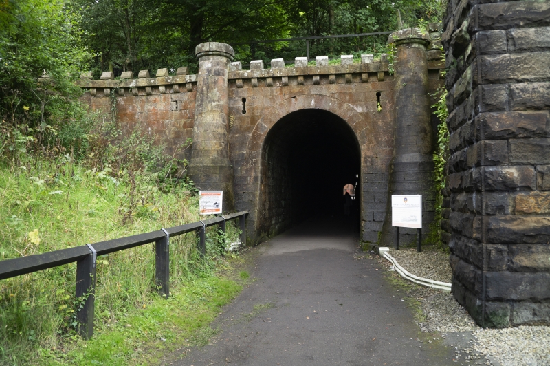
GROSMONT NORTH YORK MOORS
NZ 80 NW
RAILWAY
3/138 Pedestrian Subway
approximately one
hundred and ten
metres long
GV II*
Tramway tunnel, now pedestrian subway. c.1834. By George Stephenson for the Whitby and
Pickering Railway Company. Bordered tooled sandstone. North entrance:
battered retaining wall contains single round-arched entrance between
tapering cylindrical turrets on tall chamfered bases. Machicolated cornice
with castellated parapet runs above arch between turrets which have flat
circular caps. Retaining wall to east curves against hillside anti
terminates in low cylindrical pier with machicolated flat cap. Wall west
of arch dies into hillside. South entrance: repeats north entrance without
castellated parapet above arch. The subway was originally the horse
tramway tunnel on the Whitby to Pickering railway line and became obsolete
c.1847 when superseded by a steam tunnel (q.v.) built alongside by the York
and North Midland Railway Company.
Listing NGR: NZ8282205096
External links are from the relevant listing authority and, where applicable, Wikidata. Wikidata IDs may be related buildings as well as this specific building. If you want to add or update a link, you will need to do so by editing the Wikidata entry.


Other nearby listed buildings
