Approximate Location Map
Large Map »
Latitude: 54.2799 / 54°16'47"N
Longitude: -1.2787 / 1°16'43"W
OS Eastings: 447061
OS Northings: 487378
OS Grid: SE470873
Mapcode National: GBR MLHY.YJ
Mapcode Global: WHD8B.BPBB
Plus Code: 9C6W7PHC+XG
Entry Name: Manor House
Listing Date: 20 June 1966
Grade: II
Source: Historic England
Source ID: 1150811
English Heritage Legacy ID: 332562
ID on this website: 101150811
Location: Kirby Knowle, North Yorkshire, YO7
County: North Yorkshire
District: Hambleton
Civil Parish: Kirby Knowle
Traditional County: Yorkshire
Lieutenancy Area (Ceremonial County): North Yorkshire
Tagged with: House
KIRBY KNOWLE MAIN STREET
SE 48 NE
(EAST END, OFF)
4/28 MANOR HOUSE
20.6.66
GV II
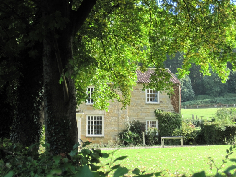
Farmhouse. Late C18 with later alterations and early C19 and C20 additions.
Coursed squared herringbone-tooled stone, Welsh slate roof. 2 Storeys, 2 bays
with C19 block added to rear right corner, a C20 block (not of special interest)
added in front angle so formed, and an outshut to rear of main range which
continues along side of C19 addition. Main range: central half-glazed door with
interlaced glazing bars in pilastered and dentil-corniced wood surround with
corbelled hood. To either side a 20-pane sash in flush wood surround, and two
similar unequally-hung 15-pane sashes above, all with plain stone lintels and
projecting cills. Shaped kneelers, ashlar coping. End stacks. Single-storey
C20 bay on right not of special interest. Rear: only 1st floor of main range is
visible and it has a central 8-pane side-sliding sash with keyed lintel. The
C19 addition has a similar window to right, a hipped roof and brick stacks.
Left return, main range: a 16-pane sash to ground floor left and a small
rectangular opening in gable. Right return, C19 addition: some 16-pane sashes
with tripartite lintels and on ground floor to left a 12-pane sash with side
lights and similar lintel eaves band.
Listing NGR: SE4706187378
External links are from the relevant listing authority and, where applicable, Wikidata. Wikidata IDs may be related buildings as well as this specific building. If you want to add or update a link, you will need to do so by editing the Wikidata entry.


Other nearby listed buildings
