Approximate Location Map
Large Map »
Latitude: 51.7038 / 51°42'13"N
Longitude: -0.6159 / 0°36'57"W
OS Eastings: 495741
OS Northings: 201472
OS Grid: SP957014
Mapcode National: GBR F5W.141
Mapcode Global: VHFS9.8FRP
Plus Code: 9C3XP93M+GJ
Entry Name: 65-69, Church Street
Listing Date: 7 September 1973
Grade: II
Source: Historic England
Source ID: 1158495
English Heritage Legacy ID: 43534
ID on this website: 101158495
Location: Chesham, Buckinghamshire, HP5
County: Buckinghamshire
Civil Parish: Chesham
Built-Up Area: Chesham
Traditional County: Buckinghamshire
Lieutenancy Area (Ceremonial County): Buckinghamshire
Church of England Parish: Great Chesham
Church of England Diocese: Oxford
Tagged with: Building
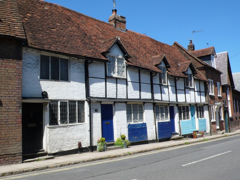
CHURCH STREET
1.
967
(North Side)
Nos 65 to 69 (odd)
SP 9501 SE 1/229
II GV
2.
C17 and C18. Timber frame, brick nogging, old tiled roof. Single storey and
attics, 4 ground floor lattice casements, 3 gabled casement dormers. Shutters
to ground floor windows, all under narrow continuous wooden hood on brackets.
RCHM, Bucks, I, 94.
Nos 63 to 73 (odd) form a group.
Listing NGR: SP9573801472
External links are from the relevant listing authority and, where applicable, Wikidata. Wikidata IDs may be related buildings as well as this specific building. If you want to add or update a link, you will need to do so by editing the Wikidata entry.


Other nearby listed buildings
