Approximate Location Map
Large Map »
Latitude: 51.9368 / 51°56'12"N
Longitude: -0.678 / 0°40'40"W
OS Eastings: 490982
OS Northings: 227306
OS Grid: SP909273
Mapcode National: GBR F2W.HDW
Mapcode Global: VHFR3.6LF2
Plus Code: 9C3XW8PC+PR
Entry Name: Grange Mill
Listing Date: 7 March 1979
Grade: II
Source: Historic England
Source ID: 1158600
English Heritage Legacy ID: 35977
ID on this website: 101158600
Location: Old Linslade, Central Bedfordshire, LU7
County: Central Bedfordshire
Civil Parish: Heath and Reach
Traditional County: Bedfordshire
Lieutenancy Area (Ceremonial County): Bedfordshire
Church of England Parish: Heath and Reach
Church of England Diocese: St.Albans
Tagged with: Mill
1.
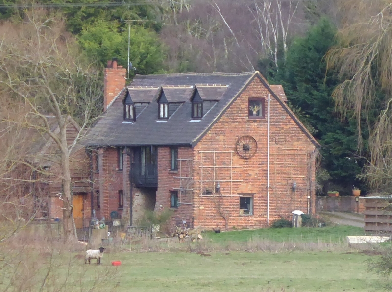
5125 HEATH AND REACH OLD LINSDALE ROAD
Grange Mill
SP 92 NW 9/148 7.3.79
II
2.
C17 with later additions. Grey and red brick. Two storey mid attics. Clay tile
roof. Casement windows with glazing bars. First floor has weatherboarded centre.
Buttresses to right hand side. Timber-framing visible in right hand elevation.
Listing NGR: SP9098227306
External links are from the relevant listing authority and, where applicable, Wikidata. Wikidata IDs may be related buildings as well as this specific building. If you want to add or update a link, you will need to do so by editing the Wikidata entry.


Other nearby listed buildings
