Approximate Location Map
Large Map »
Latitude: 50.6352 / 50°38'6"N
Longitude: -3.6454 / 3°38'43"W
OS Eastings: 283732
OS Northings: 83012
OS Grid: SX837830
Mapcode National: GBR QN.LC48
Mapcode Global: FRA 377D.CMF
Plus Code: 9C2RJ9P3+3R
Entry Name: Engine House About 140 Metres South of Canonteign Barton
Listing Date: 9 March 1988
Grade: II
Source: Historic England
Source ID: 1163737
English Heritage Legacy ID: 85592
ID on this website: 101163737
Location: Coombe, Teignbridge, Devon, EX6
County: Devon
District: Teignbridge
Civil Parish: Christow
Traditional County: Devon
Lieutenancy Area (Ceremonial County): Devon
Church of England Parish: Christow St James
Church of England Diocese: Exeter
Tagged with: Chimney
CHRISTOW
SX 88 SW
5/73 Engine House about 140 metres
south of Canonteign Barton
GV II
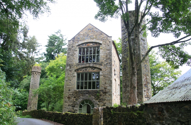
Engine house at Wheal Exmouth lead and barytes mine. 1853. Stone rubble with ashlar
granite dressings. Unusually ornamental, in a classical style to match the adjacent
octagonal ventilation shaft (q.v.).
Plan: Rectangular on plan with a large doorway on the south west side, facing the
road.
Exterior: Originally 3 storeys, top storey incomplete. Grand rusticated granite
round-headed doorway on south west side with a keystone, rusticated granite quoins.
The doorway retains a timber frame with glazing bars, presumably for margin panes and
an incomplete 2-leaf arched door with plain panelling. The south east elevation,
clad in ivy, with a narrow ground floor doorway and first floor doorway with
surviving timber frame, second floor window with 6-pane timber frame. The north east
elevation has a round headed ground floor window with ashlar masonry, a keystone and
a timber frame with glazing bars ; the north west elevation has 2 ground floor
windows with segmental arches, ashlar voussoirs and 6-pane timber frames.
Wheal Exmouth, operating from the 1850s to 1880, employed 70 underground workers in
1863. The site of the mine was visible from Canonteign House (q.v.), the Exmouth
family seat built in 1828 but later screened from it by tree planting. The ornate
style was presumably employed for the sake of the view from Canonteign House.
Listing NGR: SX8373283012
External links are from the relevant listing authority and, where applicable, Wikidata. Wikidata IDs may be related buildings as well as this specific building. If you want to add or update a link, you will need to do so by editing the Wikidata entry.


Other nearby listed buildings
