Approximate Location Map
Large Map »
Latitude: 50.8584 / 50°51'30"N
Longitude: -3.3929 / 3°23'34"W
OS Eastings: 302059
OS Northings: 107462
OS Grid: ST020074
Mapcode National: GBR LN.V67X
Mapcode Global: FRA 36ST.VBK
Plus Code: 9C2RVJ54+8R
Entry Name: 28 High Street
Listing Date: 5 April 1966
Last Amended: 24 August 2022
Grade: II
Source: Historic England
Source ID: 1168774
English Heritage Legacy ID: 95307
ID on this website: 101168774
Location: Cullompton, Mid Devon, EX15
County: Devon
District: Mid Devon
Civil Parish: Cullompton
Built-Up Area: Cullompton
Traditional County: Devon
Lieutenancy Area (Ceremonial County): Devon
Church of England Parish: Cullompton
Church of England Diocese: Exeter
Tagged with: Bank building
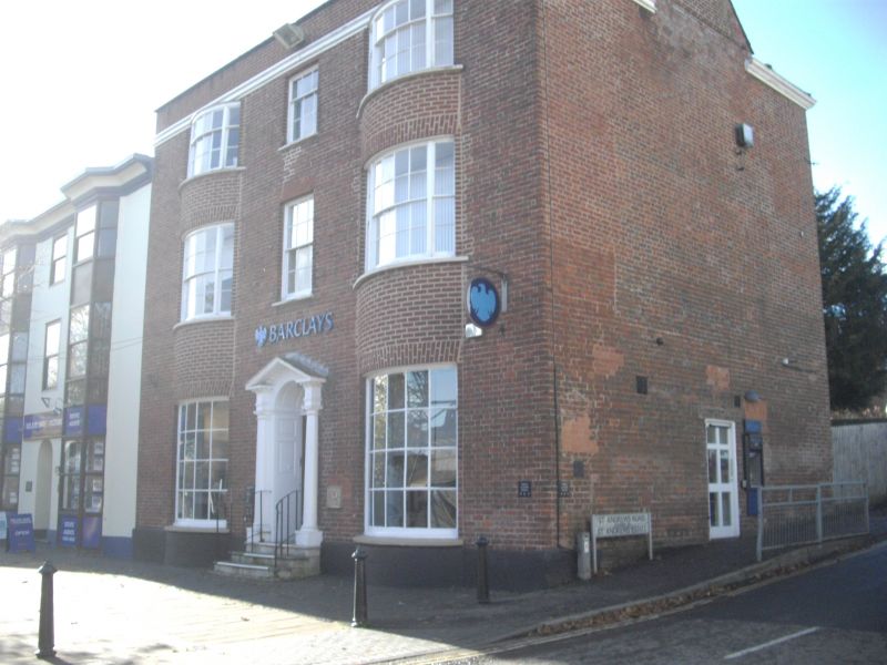
Former house, subsequently in use as a bank, and now in office use. Built around the 1780s.
CULLOMPTON HIGH STREET (west side), ST 00 NW Cullompton 10/117 No 28 5.4.66
GV II
Former house, subsequently in use as a bank, and now in office use. Built around the 1780s.
MATERIALS: brick, with a double hipped slate roof concealed behind the parapet.
PLAN: the main block faces the street, with a wing to the rear. There are flanking brick chimney stacks.
EXTERIOR: three storeys with a symmetrical, three-bay range to the front. The outer bays have bowed window bays, extending from the ground to the base of the parapet. These bowed windows were probably added in the early C19 and the flat, brick arches to them are of Flemish bond, along with the extreme left-hand section of the front, whilst the areas between the windows are in stretcher bond. The rest of the front is of an unusual variant of Flemish bond, with each course comprising two headers between each stretcher. To the ground floor, there are two C20, twenty-pane bow windows. The first- and second-floor bow windows are hornless tripartite sashes, with eight-over-eight pane sashes to the centre, flanked by two-over-two pane sashes on the first floor. On the second floor, the central sashes have four panes to the top and eight below, flanked on either side by one-over-two pane sashes. The middle bay has hornless sash windows to the first and second floors, the first-floor sash having six panes to both the top and bottom, and the second floor having three panes above and six below. The central doorway has an open pediment, engaged Tuscan columns, fielded panel reveals and soffit to a semi-circular-headed door with a fanlight above. It is approached by three steps with C20 railings. The right-hand elevation facing St Andrews Road has no windows and one doorway. To the rear there are two tripartite, hornless sash windows with crown glass to the first and second floors, the former with two panes up and two below to the side lights and six panes above and six below to the centre sash; the latter window with one pane up and two below to the side lights and three panes above and six below to the centre. To the second floor, there is another sash window, with three panes above and six panes below. There is a semi-circular headed stairwell window with intersecting glazing bars to a twelve-pane sash, which appears to have been subsequently lengthened by nine panes. The rear wing has a four-light casement window to the ground floor, with twelve leaded panes to each light and a big floriated catch. To the first floor, there is a two-light casement window, with eighteen leaded panes to each light, and a three-light casement window with a ring catch to the second floor, which has fifteen leaded panes per light. The gabled end elevation of the rear wing has a four-light casement window at second-floor level, with eighteen leaded panes per light.
Listing NGR: ST0205907462
Architectural interest:
* as a building originating in the late C18 that retains a significant proportion of its historic fabric;
* an attractive brick façade, adapted, probably in the early C19, to include a wide bow on either side, reflecting architectural fashions of the Regency period.
Group value:
* as one of a group of listed buildings in the Higher Bullring which together demonstrate the architectural development and diversity of the town.
External links are from the relevant listing authority and, where applicable, Wikidata. Wikidata IDs may be related buildings as well as this specific building. If you want to add or update a link, you will need to do so by editing the Wikidata entry.


Other nearby listed buildings
