Approximate Location Map
Large Map »
Latitude: 54.1471 / 54°8'49"N
Longitude: -2.0462 / 2°2'46"W
OS Eastings: 397076
OS Northings: 472364
OS Grid: SD970723
Mapcode National: GBR GN4H.S4
Mapcode Global: WHB6G.J1T2
Plus Code: 9C6V4XW3+RG
Entry Name: The Vicarage
Listing Date: 10 September 1954
Last Amended: 4 May 1989
Grade: II
Source: Historic England
Source ID: 1173619
English Heritage Legacy ID: 324689
ID on this website: 101173619
Location: Kettlewell, North Yorkshire, BD23
County: North Yorkshire
District: Craven
Civil Parish: Kettlewell with Starbotton
Traditional County: Yorkshire
Lieutenancy Area (Ceremonial County): North Yorkshire
Tagged with: Clergy house
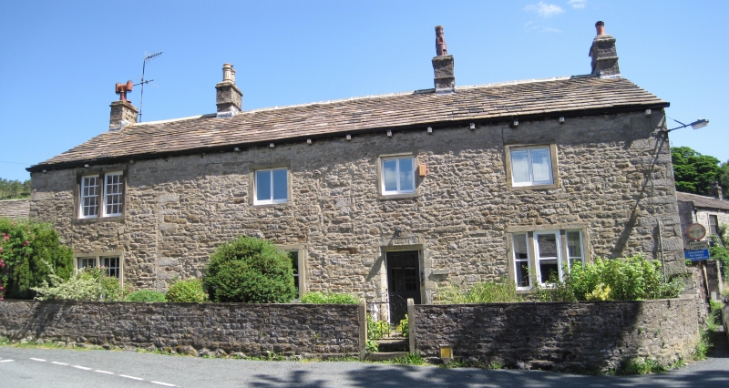
SD 9672-9772 KETTLEWELL WITH STARBOTTON KETTLEWELL
21/103 The Vicarage,
(formerly listed as
10.9.54 the Old Vicarage)
GV II
Vicarage. Dated 1647, refronted and extended in late C18. Limestone
rubble, gritstone dressings, graduated stone slate roof. 2 storeys, 3 x 2
bays plus added bay to left. Quoins. Central half-glazed door in weathered
moulded surround with quoined jambs and lintel dated "1647". Traces of a
blocked doorway to left window in bay 1. Fenestration, ground floor: 3-
light flat-faced mullioned windows with sashes flank the entrance; 3 square
windows with plain surrounds above. Paired sashes with glazing bars in
plain surrounds far left, a similar window above. Plain banded stack far
left; more elaborate stacks with moulded cornices flank the original 3 bays
of the house, similar to ridge between bays 3 and 4. Rear glazed door in
surround with chamfered quoined jambs, centre; a 2-light window with hollow
chamfers is set low down to the left, with a C20 window left again. A
small-paned sash above the door, with a similar window to right. Eaves
stacks to bays 1 and 4. Right return: quoins, right, and the line of the
C17 gable are visible, with a small round-headed hollow-chamfered window to
the first floor, left.
Listing NGR: SD9707672364
External links are from the relevant listing authority and, where applicable, Wikidata. Wikidata IDs may be related buildings as well as this specific building. If you want to add or update a link, you will need to do so by editing the Wikidata entry.


Other nearby listed buildings
