Approximate Location Map
Large Map »
Latitude: 52.7082 / 52°42'29"N
Longitude: 1.3373 / 1°20'14"E
OS Eastings: 625542
OS Northings: 317503
OS Grid: TG255175
Mapcode National: GBR WGV.8WG
Mapcode Global: WHMT8.J605
Plus Code: 9F43P85P+7W
Entry Name: Stanninghall Farm Barn
Listing Date: 16 May 1984
Grade: II
Source: Historic England
Source ID: 1178260
English Heritage Legacy ID: 228192
ID on this website: 101178260
Location: Broadland, Norfolk, NR12
County: Norfolk
District: Broadland
Civil Parish: Horstead with Stanninghall
Traditional County: Norfolk
Lieutenancy Area (Ceremonial County): Norfolk
Church of England Parish: Frettenham
Church of England Diocese: Norwich
Tagged with: Barn
TG 21 NE HORSTEAD WITH STANNINGHALL STANNINGHALL ROAD
4/59 (Stanninghall Farm)
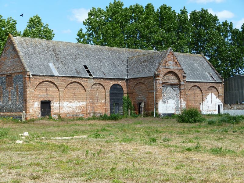
Stanninghall Farm Barn.
G.V. II
Barn, late C17, built of red brick and knapped flint, with asbestos roofs.
"Monumental" barn of cross shaped plan, formed by porches, centrally placed
to north and south. Random bonded brickwork. Flint or brick plinth, with
blind arcades with segmental arches. 4 bays to either side of 1 bay porches.
Vent slits within the arches. Clasping pilasters. Porch doors now infilled,
but retaining oak lintels and double revealed semi-circular brick arches.
South porch has moulded brick platband above the lintel, with platband above,
and stepped blank panel within the gable. The clasping pilasters here have
capitals. West gable of knapped flint with 3 vent slits, and raised blocked
opening. Eaves level platband, tie irons and owl hole. East gable has 3
blocked vent slits, hayloft door with segmental arch in recessed arched opening,
with eaves level platband stepped over it. Tie irons and owl hole. Parapet
gables with moulded brick kneelers and gable peak finials. Inserted barn doors,
either side of porches, to north and south. 14 bay staggered butt purlin roof
with 8 tie beams. Estate owned by Sir Charles Harbord, Surveyor General to
Charles 11, died 1687, and by his Son, William Harbord, Surveyor General, Land
Revenues of the crown in 1682. Percy Millican A history of Horstead and
[Stanninghall, Norfolk.]
Listing NGR: TG2554217503
External links are from the relevant listing authority and, where applicable, Wikidata. Wikidata IDs may be related buildings as well as this specific building. If you want to add or update a link, you will need to do so by editing the Wikidata entry.


Other nearby listed buildings
