Approximate Location Map
Large Map »
Latitude: 51.2629 / 51°15'46"N
Longitude: 0.3772 / 0°22'37"E
OS Eastings: 565953
OS Northings: 154212
OS Grid: TQ659542
Mapcode National: GBR NPQ.L6H
Mapcode Global: VHJMB.HJ86
Plus Code: 9F32797G+5V
Entry Name: Herne Cottage
Listing Date: 19 April 1985
Grade: II
Source: Historic England
Source ID: 1185763
English Heritage Legacy ID: 178858
ID on this website: 101185763
Location: Herne Pound, Tonbridge and Malling, Kent, ME18
County: Kent
District: Tonbridge and Malling
Civil Parish: Mereworth
Traditional County: Kent
Lieutenancy Area (Ceremonial County): Kent
Church of England Parish: Mereworth St Lawrence
Church of England Diocese: Rochester
Tagged with: Cottage
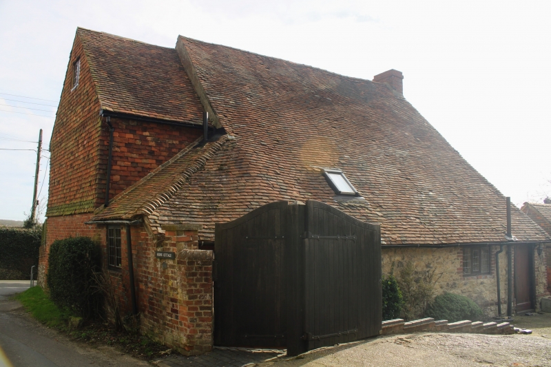
TQ 65 SE MEREWORTH BUTCHER'S LANE
(west side)
2/14 No 103 (Herne Cottage)
GV II
Cottage. C18. Coursed stone blocks with flint galletting and red brick quoins
and window dressings. Plain tiled roof with 1 dormer and catslide to rear.
2 storeys, 4 windows, C19 easements. Central coupled doors with flat hood
arm.
Listing NGR: TQ6595354212
External links are from the relevant listing authority and, where applicable, Wikidata. Wikidata IDs may be related buildings as well as this specific building. If you want to add or update a link, you will need to do so by editing the Wikidata entry.


Other nearby listed buildings
