Approximate Location Map
Large Map »
Latitude: 52.4622 / 52°27'43"N
Longitude: 1.5667 / 1°34'0"E
OS Eastings: 642392
OS Northings: 290900
OS Grid: TM423909
Mapcode National: GBR XMD.LXP
Mapcode Global: VHM6K.3CMT
Plus Code: 9F43FH68+VM
Entry Name: Pinfold (At Junction with Common Lane North)
Listing Date: 22 September 1971
Grade: II
Source: Historic England
Source ID: 1186940
English Heritage Legacy ID: 363033
ID on this website: 101186940
Location: Beccles, East Suffolk, NR34
County: Suffolk
District: East Suffolk
Civil Parish: Beccles
Built-Up Area: Beccles
Traditional County: Suffolk
Lieutenancy Area (Ceremonial County): Suffolk
Church of England Parish: Beccles St Michael and Saint Luke
Church of England Diocese: St.Edmundsbury and Ipswich
Tagged with: Animal pound
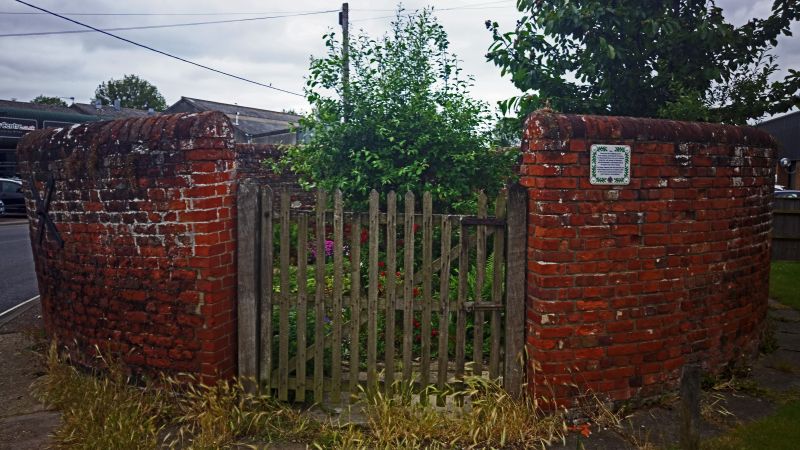
POUND ROAD
1.
828
Pinfold (at junction with
Common Lane North)
TM 4290 3/170
II
2.
18th century circular cattle pond with red brick wall about 6 ft high
with rounded cope. Entrance with double doors on west.
Listing NGR: TM4239290900
External links are from the relevant listing authority and, where applicable, Wikidata. Wikidata IDs may be related buildings as well as this specific building. If you want to add or update a link, you will need to do so by editing the Wikidata entry.


Other nearby listed buildings
