Approximate Location Map
Large Map »
Latitude: 51.1162 / 51°6'58"N
Longitude: -0.1895 / 0°11'22"W
OS Eastings: 526816
OS Northings: 136775
OS Grid: TQ268367
Mapcode National: GBR JKD.T28
Mapcode Global: VHGSW.N6NM
Plus Code: 9C3X4R86+F5
Entry Name: The Old Punchbowl
Listing Date: 21 June 1948
Last Amended: 23 February 1983
Grade: II*
Source: Historic England
Source ID: 1187086
English Heritage Legacy ID: 363350
Also known as: National Westminster Bank
ID on this website: 101187086
Location: Crawley, West Sussex, RH10
County: West Sussex
District: Crawley
Electoral Ward/Division: Northgate
Parish: Non Civil Parish
Built-Up Area: Crawley
Traditional County: Sussex
Lieutenancy Area (Ceremonial County): West Sussex
Church of England Parish: Crawley St John the Baptist
Church of England Diocese: Chichester
Tagged with: Pub
This list entry was subject to a Minor Amendment on 23 December 2021 to update the name and address and to reformat the text to current standards
TQ 2636 NE
5/27
HIGH STREET (east side)
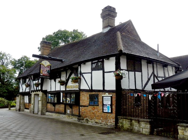
No 101 (The Old Punchbowl)
(Formerly listed as No 101 (National Westminster Bank), previously list as The Punch Bowl)
21.6.48
II*
Early C15 timber-framed hall-house of Wealden type. Five bays in all. The hall of two bays. Two storeys timber-framed with plaster infilling and brick to ground floor on stone base. Old tiled roof hipped at south end with gablet. External brick chimney stack to north with semi-circular projection containing bread oven. Four renewed casement windows. The upper storeys of the north and south ends are jettied and their wall plates are extended in advance of the middle section and supported on curved braces.
Hall of two bays with open timber roof, cambered tie-beam carrying plain King-post supporting collar and central purlin. A chimney and floor inserted in C16 and extended northward one bay within 100 years of the original buildings, contains ground and first floor rooms, first floor oversailing to the south and underbuilt in brick in the late C17 or early C18. Modern back additions to east.
The building was once a farmhouse known as The Mitchells.
(See V C H Sussex VII, 145 Sussex Archaeological Collections Vol LV (1912) pp 139-143, and Sussex County Magazine iv 16, 17).
Listing NGR: TQ2681636775
External links are from the relevant listing authority and, where applicable, Wikidata. Wikidata IDs may be related buildings as well as this specific building. If you want to add or update a link, you will need to do so by editing the Wikidata entry.


Other nearby listed buildings
