Approximate Location Map
Large Map »
Latitude: 51.114 / 51°6'50"N
Longitude: -0.1908 / 0°11'26"W
OS Eastings: 526736
OS Northings: 136529
OS Grid: TQ267365
Mapcode National: GBR JKL.0M4
Mapcode Global: VHGSW.N809
Plus Code: 9C3X4R75+JM
Entry Name: 34 and 36, High Street
Listing Date: 23 February 1983
Grade: II
Source: Historic England
Source ID: 1187087
English Heritage Legacy ID: 363353
ID on this website: 101187087
Location: Crawley, West Sussex, RH10
County: West Sussex
District: Crawley
Electoral Ward/Division: West Green
Parish: Non Civil Parish
Built-Up Area: Crawley
Traditional County: Sussex
Lieutenancy Area (Ceremonial County): West Sussex
Church of England Parish: Crawley St John the Baptist
Church of England Diocese: Chichester
Tagged with: Building
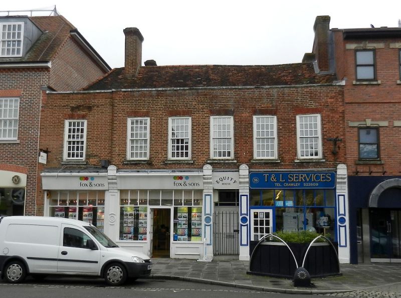
HIGH STREET
1.
5403
(West side)
Nos 34 and 36
TQ 2636 NE 5/31
II
2.
Late C18. Two storeys. Upper floor red brick. Five sash windows with glazing bars
intact and a further sash to the south where the wall is recessed over a carriageway.
Flat parapet. Tiled roof behind with 2 C18 brick chimneys. Modern shopfronts.
Listing NGR: TQ2673636529
External links are from the relevant listing authority and, where applicable, Wikidata. Wikidata IDs may be related buildings as well as this specific building. If you want to add or update a link, you will need to do so by editing the Wikidata entry.


Other nearby listed buildings
