Approximate Location Map
Large Map »
Latitude: 54.4835 / 54°29'0"N
Longitude: -1.0305 / 1°1'49"W
OS Eastings: 462907
OS Northings: 510223
OS Grid: NZ629102
Mapcode National: GBR PJ7L.PK
Mapcode Global: WHF8M.4KJR
Plus Code: 9C6WFXM9+9Q
Entry Name: Percy Rigg Farmhouse and Attached Cowhouse Range
Listing Date: 30 October 1990
Grade: II
Source: Historic England
Source ID: 1189237
English Heritage Legacy ID: 333194
ID on this website: 101189237
Location: North Yorkshire, YO21
County: North Yorkshire
District: Hambleton
Town: Hambleton
Civil Parish: Kildale
Traditional County: Yorkshire
Lieutenancy Area (Ceremonial County): North Yorkshire
Church of England Parish: Kildale St Cuthbert
Church of England Diocese: York
Tagged with: Farmhouse
KILDALE PERCY CROSS RIG
NZ 61 SW
North-east side
(off)
2/135 Percy Rigg
Farmhouse and
attached cowhouse
range
II
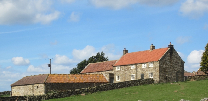
Farmhouse and attached cowhouse range. Probably c.1700, raised and
remodelled 1783 for Charles Turner (datestone); later alterations.
Cowhouse range late C18 and early C19. Rubblestone brought to
course; pantile roofs with stone coping and ridges. 2-storey, 3-bay
house with lower cowhouse with loft over with further cowhouse
ranges added to front of it, forming courtyard, on left. Garden
elevation: farmhouse: plinth. Blocked doorway on right of bay 1.
Doorway on left of bay 3 with C20 board door. Tripartite sash
windows with projecting sills; inserted C20 first-floor window to
left of right bay. Ground-floor openings have herringbone-tooled
lintels with raised keystones, that over door dated. Eaves band.
Shaped kneelers. Stacks at end and between right bays. Cowhouse on
left masked by later courtyard which is lower; of coursed rubble,
with plinth, quoins, eaves band, some blocked and some later
openings, and hipped roof, the pantiles partly replaced by corrugated
asbestos. Rear: house: C20 gabled brick porch. Various C19 and
C20 windows with herringbone-tooled sills and lintels, but a 12-pane
side-sliding sash survives on 1st floor, centre. Eaves band.
Shaped kneelers. Cowhouse: board door to left; inserted double
door on right with blocked doorway to its right. Slit vents and
blocked pitching hole to left gable of cowhouse.
Charles Turner, for whom this house was built (or rebuilt) was an
agricultural improver who built or rebuilt, a number of farmhouses
on the Kildale Estate.
Listing NGR: NZ6290710223
External links are from the relevant listing authority and, where applicable, Wikidata. Wikidata IDs may be related buildings as well as this specific building. If you want to add or update a link, you will need to do so by editing the Wikidata entry.


Other nearby listed buildings
