Approximate Location Map
Large Map »
Latitude: 54.4473 / 54°26'50"N
Longitude: -1.2795 / 1°16'46"W
OS Eastings: 446819
OS Northings: 506005
OS Grid: NZ468060
Mapcode National: GBR MKH0.SJ
Mapcode Global: WHD7K.9GYZ
Plus Code: 9C6WCPWC+W6
Entry Name: Enterpen Farmhouse and Attached Stable
Listing Date: 8 May 1989
Last Amended: 3 January 1996
Grade: II
Source: Historic England
Source ID: 1189352
English Heritage Legacy ID: 333034
ID on this website: 101189352
Location: Hutton Rudby, North Yorkshire, TS15
County: North Yorkshire
District: Hambleton
Civil Parish: Hutton Rudby
Built-Up Area: Hutton Rudby
Traditional County: Yorkshire
Lieutenancy Area (Ceremonial County): North Yorkshire
Church of England Parish: Rudby-in-Cleveland All Saints
Church of England Diocese: York
Tagged with: Farmhouse
NZ 4606 and NZ 40 NE
13/105 and 5/105
HUTTON RUDBY
ENTERPEN
(south-east side),
Enterfen Farmhouse and attached stable
II
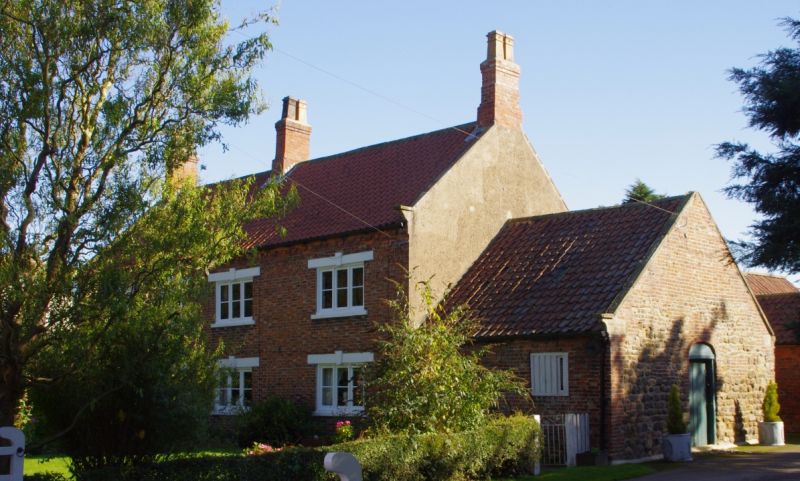
Farmhouse and stable. C18. Red brick in Flemish bond with grey headers;
rendered returns; stone and brick return stable wall. Pantiled roof with stone
copings and kneelers, brick chimneys. Hearth-passage plan, but both ends of
equal height and status. 2 storeys, 4 windows. In second bay a 6-panel door,
top glazed with trompe l'oeil window above. Other windows 3-light C19 1-bar
casements. Keyed extended lintels; to all openings. Brick dentilled eaves
cornice. Set-back 1-storey, 2-bay left extension with 16-pane sashes. Right
1-storey stable has hit-and-miss window. Right return of stable shows stonework
to eaves, brick above (perhaps once a lean-to) and wagon entrance with boarded
door and segmental brick arch. Later 1-storey rear extensions are not of
special interest.
Listing NGR: NZ4681906005
External links are from the relevant listing authority and, where applicable, Wikidata. Wikidata IDs may be related buildings as well as this specific building. If you want to add or update a link, you will need to do so by editing the Wikidata entry.


Other nearby listed buildings
