Approximate Location Map
Large Map »
Latitude: 51.6676 / 51°40'3"N
Longitude: -1.2783 / 1°16'41"W
OS Eastings: 450010
OS Northings: 196787
OS Grid: SU500967
Mapcode National: GBR 7YR.FMT
Mapcode Global: VHCY6.SBLX
Plus Code: 9C3WMP9C+3M
Entry Name: The Maud Hales Bridge
Listing Date: 18 July 1963
Grade: II
Source: Historic England
Source ID: 1194433
English Heritage Legacy ID: 248814
ID on this website: 101194433
Location: Abingdon-on-Thames, South Oxfordshire, OX14
County: Oxfordshire
District: South Oxfordshire
Civil Parish: Culham
Built-Up Area: Abingdon
Traditional County: Oxfordshire
Lieutenancy Area (Ceremonial County): Oxfordshire
Church of England Parish: Culham
Church of England Diocese: Oxford
Tagged with: Bridge
CULHAM A415
SU59NW Abingdon
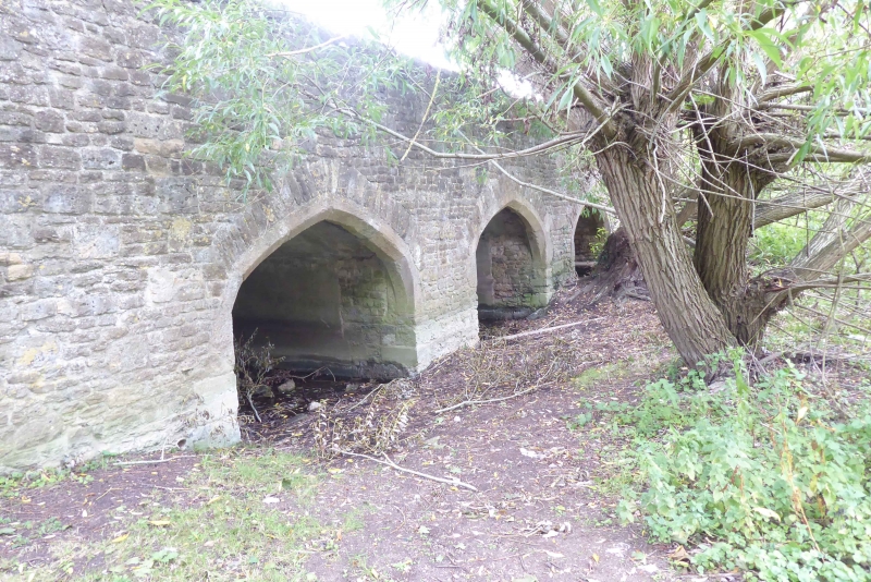
2/29 The Maud Hales Bridge
18/07/63
GV II
Bridge. c.1416, built by the Abingdon Guild of the Holy Cross, widened and
partly rebuilt c,1927. Squared uncoursed stone. 3 segmental pointed arches.
Plain parapet. Forms continuation of Abingdon Bridge. Scheduled Ancient
Monument.
(V.C.H.: Oxfordshire, Vol.7, 1962; p.27).
Listing NGR: SU5001096787
External links are from the relevant listing authority and, where applicable, Wikidata. Wikidata IDs may be related buildings as well as this specific building. If you want to add or update a link, you will need to do so by editing the Wikidata entry.


Other nearby listed buildings
