Approximate Location Map
Large Map »
Latitude: 51.4585 / 51°27'30"N
Longitude: -2.5936 / 2°35'37"W
OS Eastings: 358852
OS Northings: 173445
OS Grid: ST588734
Mapcode National: GBR C8J.C0
Mapcode Global: VH88N.0L6S
Plus Code: 9C3VFC54+9G
Entry Name: White Hart Inn and Attached Wall
Listing Date: 4 March 1977
Last Amended: 30 December 1994
Grade: II
Source: Historic England
Source ID: 1202364
English Heritage Legacy ID: 379963
ID on this website: 101202364
Location: Kingsdown, Bristol, BS1
County: City of Bristol
Electoral Ward/Division: Central
Parish: Non Civil Parish
Built-Up Area: Bristol
Traditional County: Gloucestershire
Lieutenancy Area (Ceremonial County): Bristol
Church of England Parish: Bristol St Stephen with St James and St John the Baptist with St Michael and St George
Church of England Diocese: Bristol
Tagged with: Inn
BRISTOL
ST5873SE LOWER MAUDLIN STREET
901-1/11/137 (North East side)
04/03/77 White Hart Inn and attached wall
(Formerly Listed as:
LOWER MAUDLIN STREET
The White Hart Public House)
II
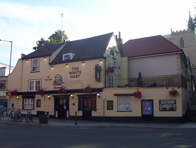
Public house. Dated 1672, refronted C19. Rendered timber-frame
with 3 rear lateral stacks and double Roman roof, hipped to
the left. Single-depth plan. 3 storeys and basement; 3-window
range. An irregular front has a banded ground floor to a
timber cornice, a pilaster strip to the left end, which has a
steeply ramped parapet up from the ground floor; the roof in 2
sections, the wider right-hand 2-storey part is steeper with a
small C20 dormer. Two C19 doorways and left-hand window have
pilaster jambs with raised panels to a fascia and cornice,
double doors with margin lights, and 3-light mullion and
transom casement window. The left-hand section has first-floor
paired 2/2-pane horned sashes in flush frames, and
second-floor sash with margin panes; right-hand left-of-centre
small horned sash. Right-hand C20 extension has a single
window. The left return has a single-storey brick parapeted
wall with a moulded string which curves round to the rear,
with a hipped roof. INTERIOR: extensively altered. SUBSIDIARY
FEATURES: attached coursed limestone wall to the left-hand
side, related to the walls and gateway to St James' Church
(qv). A vernacular building, the right-hand side is the
earlier.
Listing NGR: ST5885273445
External links are from the relevant listing authority and, where applicable, Wikidata. Wikidata IDs may be related buildings as well as this specific building. If you want to add or update a link, you will need to do so by editing the Wikidata entry.


Other nearby listed buildings
