Approximate Location Map
Large Map »
Latitude: 54.0528 / 54°3'10"N
Longitude: -1.7007 / 1°42'2"W
OS Eastings: 419693
OS Northings: 461917
OS Grid: SE196619
Mapcode National: GBR JPKK.LX
Mapcode Global: WHC84.VDBC
Plus Code: 9C6W373X+4P
Entry Name: The Royal Oak Public House
Listing Date: 3 March 1987
Grade: II
Source: Historic England
Source ID: 1203013
English Heritage Legacy ID: 331180
Also known as: Royal Oak Inn, Harrogate
ID on this website: 101203013
Location: Dacre Banks, North Yorkshire, HG3
County: North Yorkshire
District: Harrogate
Civil Parish: Dacre
Built-Up Area: Summerbridge
Traditional County: Yorkshire
Lieutenancy Area (Ceremonial County): North Yorkshire
Tagged with: Pub
DACRE MAIN STREET
SE 16 SE (east side, off)
Dacre Banks
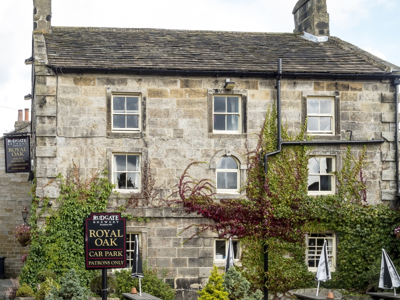
8/51 The Royal Oak Public
House
- II
Public house. Dated 1752. Grey gritstone ashlar to south front, coursed
gritstone rubble to rear and gable ends. Graduated stone slate roof. 3
storeys, 3 bays. Rusticated quoins and plinth. Central door, now window
with alternate stressed quoins and double keystone. Round-arched window in
architrave with imposts and keystone to first floor, centre; remaining
windows all have plain stone surrounds, those to ground floor being sashes
with glazing bars, the remainder 4-pane sashes. Projecting band at first
floor has inscription ' I ' above former entrance. Gable copings, end
T I
1752
stacks, that to left rebuilt. Left return: C20 entrance to right of centre;
original entrance, now window, on far left has a quoined surround as front.
2 ground-floor windows: C20 to left of centre, 8-pane sash to far right.
First floor: two 4-pane sashes in plain stone surrounds; second floor: wide
window with 2 small 4-pane sashes to left, sash window to centre, both in
stone surrounds. Gable coping continues as projecting band at eaves level
and across base of chimney stack.
Listing NGR: SE1969361917
External links are from the relevant listing authority and, where applicable, Wikidata. Wikidata IDs may be related buildings as well as this specific building. If you want to add or update a link, you will need to do so by editing the Wikidata entry.


Other nearby listed buildings
