Approximate Location Map
Large Map »
Latitude: 54.4868 / 54°29'12"N
Longitude: -0.6152 / 0°36'54"W
OS Eastings: 489807
OS Northings: 511044
OS Grid: NZ898110
Mapcode National: GBR SJ4K.LC
Mapcode Global: WHG9Y.JH86
Plus Code: 9C6XF9PM+PW
Entry Name: 40 and 41, Flowergate
Listing Date: 4 December 1972
Grade: II
Source: Historic England
Source ID: 1204359
English Heritage Legacy ID: 326765
ID on this website: 101204359
Location: Whitby, North Yorkshire, YO21
County: North Yorkshire
District: Scarborough
Civil Parish: Whitby
Built-Up Area: Whitby
Traditional County: Yorkshire
Lieutenancy Area (Ceremonial County): North Yorkshire
Church of England Parish: Whitby St Mary
Church of England Diocese: York
Tagged with: Building
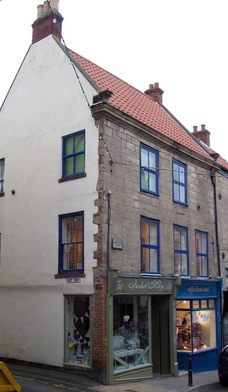
1.
18ll FLOWERGATE
(North Side)
Nos 40 & 41
NZ 8911 1/124
II
2.
First half of C18. 3 storeys in painted ashlar. Pantiles. 2 windows,
flush frames, double-hung sashes, glazing bars. To lst floor, 1:2 windows.
Late Cl9 and modern ground floor shop fronts with tiled stall risers and
modern doors.
Listing NGR: NZ8980711044
External links are from the relevant listing authority and, where applicable, Wikidata. Wikidata IDs may be related buildings as well as this specific building. If you want to add or update a link, you will need to do so by editing the Wikidata entry.


Other nearby listed buildings
