Approximate Location Map
Large Map »
Latitude: 54.9134 / 54°54'48"N
Longitude: -1.3743 / 1°22'27"W
OS Eastings: 440208
OS Northings: 557816
OS Grid: NZ402578
Mapcode National: GBR VDT.C2
Mapcode Global: WHD55.VRRN
Plus Code: 9C6WWJ7G+97
Entry Name: Retaining Wall to East of Former Graveyard of St Peter
Listing Date: 10 November 1978
Last Amended: 17 October 1994
Grade: II
Source: Historic England
Source ID: 1207127
English Heritage Legacy ID: 391583
ID on this website: 101207127
Location: Monkwearmouth, Sunderland, Tyne and Wear, SR6
County: Sunderland
Electoral Ward/Division: St Peter's
Parish: Non Civil Parish
Built-Up Area: Sunderland
Traditional County: Durham
Lieutenancy Area (Ceremonial County): Tyne and Wear
Church of England Parish: Monkwearmouth Team Ministry
Church of England Diocese: Durham
Tagged with: Retaining wall
SUNDERLAND
NZ4057 SAINT PETER'S WAY
920-1/12/208 (West side (off))
10/11/78 Retaining wall to east of former
graveyard of Church of St Peter
(Formerly Listed as:
DAME DOROTHY STREET
Retaining wall to east of former
Graveyard)
GV II
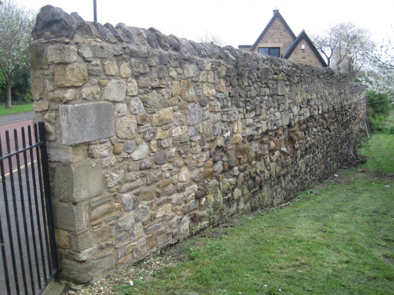
Retaining wall at east side of former graveyard to Church of
St Peter (qv). Possibly medieval foundations, probably C18
above and raised in C19. Rubble limestone and sandstone with
some granite; old brick patching and rubble coping. 2.5-3m
high, ramped up at left, with opening for entrance to vicarage
garden; beside late-C20 brick-arched steps to this opening an
C18 headstone has been set in the wall. Other headstones rest
against it. Lowest part a mixture of limestone and sandstone,
some of the latter red; central section sandstone with brick
patching; upper part limestone with brick patching and rounded
rubble coping. An ashlar block inscribed 1848 is incorporated
about one-third of length from north end; beside this a space
shows another block has been removed.
Listing NGR: NZ4020857816
External links are from the relevant listing authority and, where applicable, Wikidata. Wikidata IDs may be related buildings as well as this specific building. If you want to add or update a link, you will need to do so by editing the Wikidata entry.


Other nearby listed buildings
