Approximate Location Map
Large Map »
Latitude: 51.4492 / 51°26'57"N
Longitude: -2.593 / 2°35'34"W
OS Eastings: 358888
OS Northings: 172412
OS Grid: ST588724
Mapcode National: GBR C8M.JB
Mapcode Global: VH88N.0TKX
Plus Code: 9C3VCCX4+MR
Entry Name: Severn Shed
Listing Date: 30 December 1994
Grade: II
Source: Historic England
Source ID: 1209838
English Heritage Legacy ID: 380679
ID on this website: 101209838
Location: Bristol, BS1
County: City of Bristol
Electoral Ward/Division: Central
Parish: Non Civil Parish
Built-Up Area: Bristol
Traditional County: Gloucestershire
Lieutenancy Area (Ceremonial County): Bristol
Church of England Parish: Bristol St Stephen with St James and St John the Baptist with St Michael and St George
Church of England Diocese: Bristol
Tagged with: Architectural structure
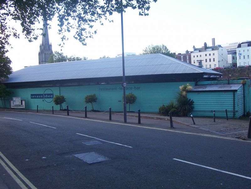
BRISTOL
ST5872 THE GROVE, Floating Harbour
901-1/42/296 (South East side)
Severn Shed
II
Formerly known as: Hide Shed THE GROVE.
Transit shed and office. 1863-4. Enclosed late C19. Cast-iron,
weatherboard cladding, with a corrugated-iron hipped roof.
Single-depth plan.
Single storey; 7-bay range. A windowless range to the road
with a 1-window end office bay with a sloping roof; divided by
plastered flush timber piers with an open section beneath
overhanging eaves, crossed by curved down pipes from the
gutter, with left-of-centre sliding doors. The left return is
2 bays, with cast-iron columns with simple foliate capitals to
elliptical-arched lattice beams. The rear facing the harbour
has 3 sets of sliding doors. INTERIOR not inspected.
HISTORICAL NOTE: the oldest transit shed in the docks,
formerly open with a slate roof, with later cladding, and
known as Hide Shed. The last surviving part of a scheme of
quayside transit shed accommodation which extended along
Redcliff Wharf and Broad Quay.
(Lord J and Southam J: The Floating Harbour: Bristol: 1983-:
51).
Listing NGR: ST5888872412
External links are from the relevant listing authority and, where applicable, Wikidata. Wikidata IDs may be related buildings as well as this specific building. If you want to add or update a link, you will need to do so by editing the Wikidata entry.
Other nearby listed buildings


