Approximate Location Map
Large Map »
Latitude: 50.7401 / 50°44'24"N
Longitude: -3.2674 / 3°16'2"W
OS Eastings: 310666
OS Northings: 94150
OS Grid: SY106941
Mapcode National: GBR P7.MZ2Y
Mapcode Global: FRA 4714.2X0
Plus Code: 9C2RPPRM+22
Entry Name: Front Garden Wall of Knightstone
Listing Date: 11 January 1974
Grade: II*
Source: Historic England
Source ID: 1213783
English Heritage Legacy ID: 398331
ID on this website: 101213783
Location: Wiggaton, East Devon, EX11
County: Devon
District: East Devon
Civil Parish: Ottery St. Mary
Traditional County: Devon
Lieutenancy Area (Ceremonial County): Devon
Church of England Parish: Ottery St Mary
Church of England Diocese: Exeter
Tagged with: Architectural structure
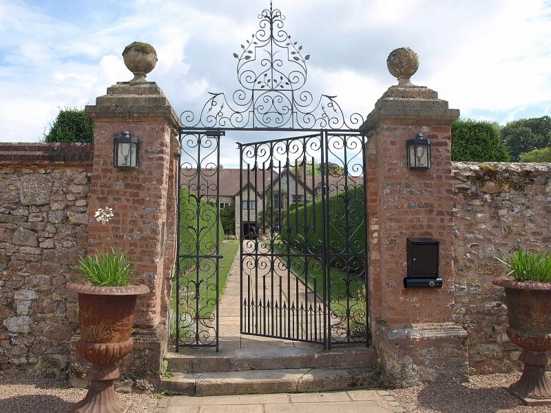
1. WIGGATON
1481 --------
Front garden wall of
Knightstone
SY 19 SW 6/91
II*
2.
C17 and earlier 8 feet high stone wall around front garden with brick square
piers with stone orb finials, wrought iron gate with side panels and overthrow.
Listing NGR: SY1066694150
External links are from the relevant listing authority and, where applicable, Wikidata. Wikidata IDs may be related buildings as well as this specific building. If you want to add or update a link, you will need to do so by editing the Wikidata entry.


Other nearby listed buildings
