Approximate Location Map
Large Map »
Latitude: 50.8462 / 50°50'46"N
Longitude: -0.6278 / 0°37'40"W
OS Eastings: 496699
OS Northings: 106078
OS Grid: SU966060
Mapcode National: GBR FJ3.XRR
Mapcode Global: FRA 96KV.Z2L
Plus Code: 9C2XR9WC+FV
Entry Name: 15-20, the Street
Listing Date: 20 September 1984
Grade: II
Source: Historic England
Source ID: 1222510
English Heritage Legacy ID: 414008
ID on this website: 101222510
Location: Walberton, Arun, West Sussex, BN18
County: West Sussex
District: Arun
Civil Parish: Walberton
Built-Up Area: Westergate
Traditional County: Sussex
Lieutenancy Area (Ceremonial County): West Sussex
Church of England Parish: Walberton
Church of England Diocese: Chichester
Tagged with: Building
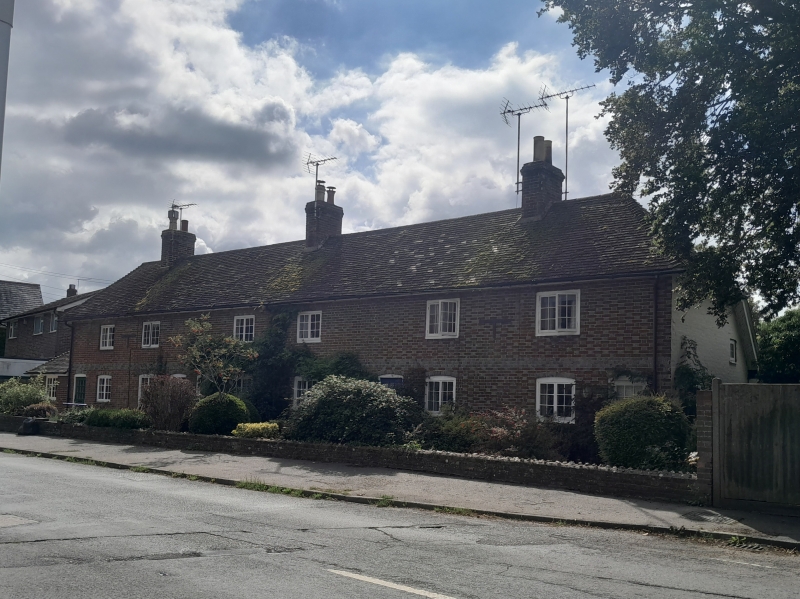
SU 90NE WALBERTON THE STREET
8/400 (south side)
Nos 15 to 20 (consec)
II
One building. Early C19. Two storeys. Six windows. Red brick and grey headers.
Flush stringcourse of grey headers. Hipped tiled roof. Casement windows.
Listing NGR: SU9669706076
External links are from the relevant listing authority and, where applicable, Wikidata. Wikidata IDs may be related buildings as well as this specific building. If you want to add or update a link, you will need to do so by editing the Wikidata entry.


Other nearby listed buildings
