Approximate Location Map
Large Map »
Latitude: 50.8537 / 50°51'13"N
Longitude: -0.5318 / 0°31'54"W
OS Eastings: 503446
OS Northings: 107046
OS Grid: TQ034070
Mapcode National: GBR GKK.JC0
Mapcode Global: FRA 96SV.0NT
Plus Code: 9C2XVF39+F7
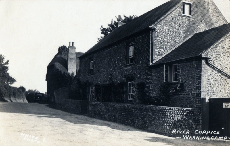
Entry Name: River Coppice
Listing Date: 20 September 1984
Grade: II
Source: Historic England
Source ID: 1222541
English Heritage Legacy ID: 414751
ID on this website: 101222541
Location: Warningcamp, Arun, West Sussex, BN18
County: West Sussex
District: Arun
Civil Parish: Warningcamp
Traditional County: Sussex
Lieutenancy Area (Ceremonial County): West Sussex
Church of England Parish: Lyminster St Mary Magdalene
Church of England Diocese: Chichester
Tagged with: Architectural structure
TQ OONW WARNINGCAMP THE STREET
9/209
River Coppice
II
C18. Two storeys. Two windows. Faced with flints with red brick dressings, quoins
and modillion eaves cornice. Slate roof. Glazing bars intact. Doorway in moulded
architrave surround with pediment over. Section at west end of lower elevation.
Listing NGR: TQ0344607046
External links are from the relevant listing authority and, where applicable, Wikidata. Wikidata IDs may be related buildings as well as this specific building. If you want to add or update a link, you will need to do so by editing the Wikidata entry.


Other nearby listed buildings
