Approximate Location Map
Large Map »
Latitude: 50.6791 / 50°40'44"N
Longitude: -3.4627 / 3°27'45"W
OS Eastings: 296754
OS Northings: 87627
OS Grid: SX967876
Mapcode National: GBR P3.3SGR
Mapcode Global: FRA 37M8.YMY
Plus Code: 9C2RMGHP+JW
Entry Name: 27, the Strand
Listing Date: 11 November 1952
Grade: II*
Source: Historic England
Source ID: 1224066
English Heritage Legacy ID: 420032
ID on this website: 101224066
Location: Topsham, Exeter, Devon, EX3
County: Devon
District: Exeter
Electoral Ward/Division: Topsham
Parish: Non Civil Parish
Built-Up Area: Topsham
Traditional County: Devon
Lieutenancy Area (Ceremonial County): Devon
Church of England Parish: Topsham St Margaret
Church of England Diocese: Exeter
Tagged with: House
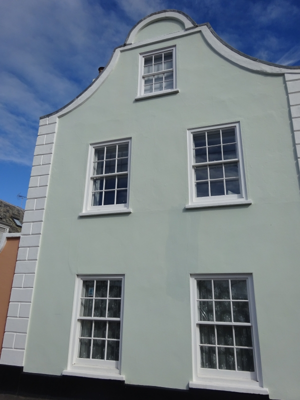
THE STRAND
1.
1092
(East Side)
TOPSHAM
No 21
(Formerly listed in the rural
district of St Thomas)
SX 9688 9/1175 11.11.52
II* GV
2.
Late C17. Stuccoed brick front with rusticated quoins. Two storeys and attic,
two windows, C19 sashes, Georgian sash in attic. Original Dutch gable.
All the listed buildings of the Strand form a group.
Listing NGR: SX9675487627
External links are from the relevant listing authority and, where applicable, Wikidata. Wikidata IDs may be related buildings as well as this specific building. If you want to add or update a link, you will need to do so by editing the Wikidata entry.


Other nearby listed buildings
