Approximate Location Map
Large Map »
Latitude: 50.9885 / 50°59'18"N
Longitude: -0.6093 / 0°36'33"W
OS Eastings: 497706
OS Northings: 121932
OS Grid: SU977219
Mapcode National: GBR FGD.W8Q
Mapcode Global: FRA 96MH.LGD
Plus Code: 9C2XX9QR+C7
Entry Name: Preyste House
Listing Date: 5 November 1973
Grade: II
Source: Historic England
Source ID: 1225900
English Heritage Legacy ID: 422820
ID on this website: 101225900
Location: Petworth, Chichester, West Sussex, GU28
County: West Sussex
District: Chichester
Civil Parish: Petworth
Built-Up Area: Petworth
Traditional County: Sussex
Lieutenancy Area (Ceremonial County): West Sussex
Church of England Parish: Petworth St Mary
Church of England Diocese: Chichester
Tagged with: House
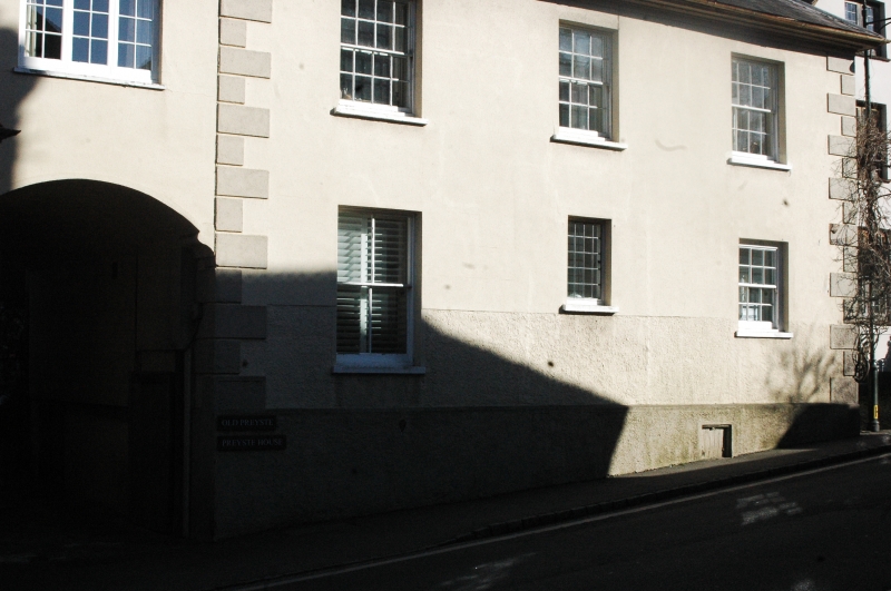
SU 9721 PETWORTH NORTH STREET
(east -side)
29/345
5.11.73 Preyste House
GV
II
House. C18. Two storeys. Three windows and one window-bay added at north end over
a carriage archway. Stuccoed. Long and short quoins. Tiled roof. Glazing bars
intact on first floor only.
Listing NGR: SU9772421935
External links are from the relevant listing authority and, where applicable, Wikidata. Wikidata IDs may be related buildings as well as this specific building. If you want to add or update a link, you will need to do so by editing the Wikidata entry.


Other nearby listed buildings
