Approximate Location Map
Large Map »
Latitude: 52.7307 / 52°43'50"N
Longitude: -1.1407 / 1°8'26"W
OS Eastings: 458124
OS Northings: 315131
OS Grid: SK581151
Mapcode National: GBR 8L9.SHK
Mapcode Global: WHDHY.GM1F
Plus Code: 9C4WPVJ5+7P
Entry Name: 2, Loughborough Road
Listing Date: 12 October 1984
Grade: II*
Source: Historic England
Source ID: 1228109
English Heritage Legacy ID: 402647
ID on this website: 101228109
Location: Mountsorrel, Charnwood, Leicestershire, LE12
County: Leicestershire
District: Charnwood
Civil Parish: Mountsorrel
Built-Up Area: Mountsorrel
Traditional County: Leicestershire
Lieutenancy Area (Ceremonial County): Leicestershire
Church of England Parish: Mountsorrel St Peter
Church of England Diocese: Leicester
Tagged with: Building
MOUNTSORREL
SK 51 NE
3/23
1.6.66
LOUGHBOROUGH ROAD (East Side)
No. 2
GV
II*
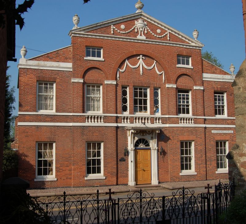
House. Dated 1788, mostly with late C19 rear. Red brick with elaborate stone
dressings, bands, cornice and coped gables, and Welsh slate roof, hipped on
side wings, with brick rear stacks. In Palladian style as if with 2 intersecting
temple fronts, the inner and higher projecting slightly forward. 2 and 3 storeys
of 5 6/6 sash windows, the centre first floor with 2 side lights, the glazing
bars forming octagons. On 2nd floor 2 6-pane swing windows. On ground floor
a central doorcase with Adam style decoration, prominent bracketed hood, 6-panelled
door and fanlight with decorated glazing bars. The decoration on the front
is also Adam inspired. A double band has balusters between under the central
windows. These have blank arches over with impost bands, the larger central
arch, which runs through both ground and first floors, enriched with swags.
Cornice band above the side windows. Central 3 storey section has modillion
corniced pediment with urn and wheat-ear garlands decoration in tympanum. 5
urns on coping. Formerly the Vicarage. Tablet on rear gable inscribed 'R.T.A.
1788' "An exceptionally elegant late C18 brick house". Pevsner.
Listing NGR: SK5812415131
External links are from the relevant listing authority and, where applicable, Wikidata. Wikidata IDs may be related buildings as well as this specific building. If you want to add or update a link, you will need to do so by editing the Wikidata entry.


Other nearby listed buildings
