Approximate Location Map
Large Map »
Latitude: 51.0583 / 51°3'30"N
Longitude: 0.4276 / 0°25'39"E
OS Eastings: 570222
OS Northings: 131582
OS Grid: TQ702315
Mapcode National: GBR NS9.DYL
Mapcode Global: FRA C6SB.2FX
Plus Code: 9F323C5H+83
Entry Name: Ketleys
Listing Date: 13 May 1987
Grade: II
Source: Historic England
Source ID: 1237640
English Heritage Legacy ID: 414612
ID on this website: 101237640
Location: Rother, East Sussex, TN5
County: East Sussex
District: Rother
Civil Parish: Ticehurst
Traditional County: Sussex
Lieutenancy Area (Ceremonial County): East Sussex
Church of England Parish: Ticehurst St Mary
Church of England Diocese: Chichester
Tagged with: Building
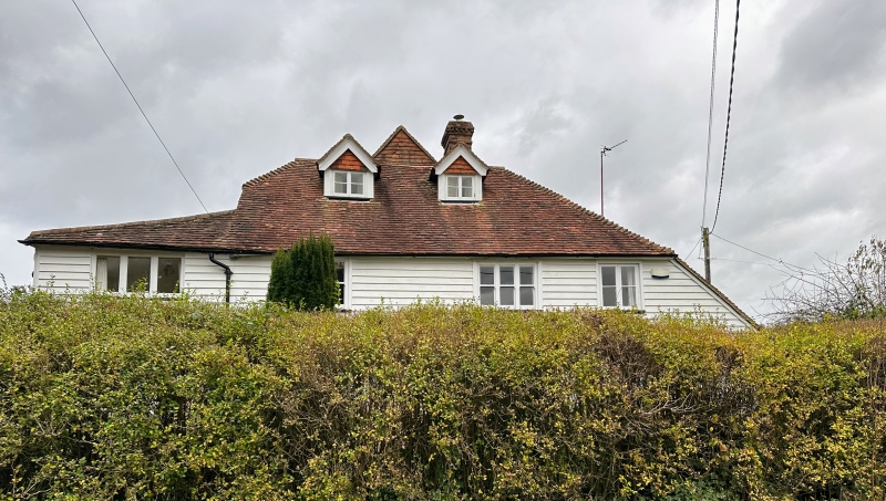
TQ 73 SW TICEHURST ROSEMARY LANE
2/2 Ketleys
II
On the map called Ketley Farm. C16 refaced. Two storeys. Three windows and
attic. Three windows. Two gabled dormers. Faced with weather-boarding. Hipped
tiled roof with pentice to south. Casement windows. Later addition of one
window-bay to north. Also higher wing behind to east.
Listing NGR: TQ7022231582
External links are from the relevant listing authority and, where applicable, Wikidata. Wikidata IDs may be related buildings as well as this specific building. If you want to add or update a link, you will need to do so by editing the Wikidata entry.


Other nearby listed buildings
